
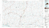
~ Emporia VA topo map, 1:100000 scale, 30 X 60 Minute, Historical, 1984, updated 1986
Emporia, Virginia, USGS topographic map dated 1984.
Includes geographic coordinates (latitude and longitude). This topographic map is suitable for hiking, camping, and exploring, or framing it as a wall map.
Printed on-demand using high resolution imagery, on heavy weight and acid free paper, or alternatively on a variety of synthetic materials.
Topos available on paper, Waterproof, Poly, or Tyvek. Usually shipping rolled, unless combined with other folded maps in one order.
- Product Number: USGS-5303640
- Free digital map download (high-resolution, GeoPDF): Emporia, Virginia (file size: 15 MB)
- Map Size: please refer to the dimensions of the GeoPDF map above
- Weight (paper map): ca. 55 grams
- Map Type: POD USGS Topographic Map
- Map Series: HTMC
- Map Verison: Historical
- Cell ID: 67478
- Scan ID: 188782
- Imprint Year: 1986
- Aerial Photo Year: 1982
- Edit Year: 1984
- Datum: NAD27
- Map Projection: Universal Transverse Mercator
- Planimetric: Yes
- Map published by United States Geological Survey
- Map Language: English
- Scanner Resolution: 600 dpi
- Map Cell Name: Emporia
- Grid size: 30 X 60 Minute
- Date on map: 1984
- Map Scale: 1:100000
- Geographical region: Virginia, United States
Neighboring Maps:
All neighboring USGS topo maps are available for sale online at a variety of scales.
Spatial coverage:
Topo map Emporia, Virginia, covers the geographical area associated the following places:
- Willow Oaks - Gray - Gum Forks - Severn - Drewryville - Gholsonville - Gaston - Hickory Run - Barrows Store - Beales - Totaro - Skippers - Branchville - North Emporia - Revistown (historical) - Poarch Store - Howells Mill - Price Mill - Piney Grove - Pine View Mobile Home Park - Henrico - James River Junction - Sturgeonville - Homeville - Valentines - Old Fitzhugh - Barley - Elams - Rawlings - Bowers Corner - Champ - Barrett Corner - Turners Crossroads - Littleton - Adsit - Sussex - Netta (historical) - Racume - Ebony - Purdy - Lumberton - Faisons Mobile Home Park - Tobacco - Turners Crossroads - Westover Hills - Fort Nottoway - Walnut Heights - Lawrenceville - White City - Delbridge Estates - Warfield - Callaville - Slates Corner - Jonesboro (historical) - Grandy - Henry - Poythress Estates - White Plains - Garners Mill - Alberta - Powellton - Druid (historical) - Hugo - Mason - Capron - Chub (historical) - Kingsberry - Oak Lawn - Stony Creek - Delaware - Baskerville Mill - Statesville - Bowens Corner - Newsoms - Radium - Lincoln Heights - Brewers Crossroads - Mount Olivet - Adams Grove - Como - Booker - Walnut Grove - Diamond Grove - Cool Spring - Halifax Manor Mobile Home Park - Brunswick - Bennets Crossroads - Gaskins (historical) - Southside Shores - Margarettsville - Edmunds Store - Harrells Mill - Manry - Edgerton - Gum - Sunbeam - Sebrell - Fort Christanna - Dons Mobile Home Park - Lawrenceville Hills
- Map Area ID: AREA3736.5-78-77
- Northwest corner Lat/Long code: USGSNW37-78
- Northeast corner Lat/Long code: USGSNE37-77
- Southwest corner Lat/Long code: USGSSW36.5-78
- Southeast corner Lat/Long code: USGSSE36.5-77
- Northern map edge Latitude: 37
- Southern map edge Latitude: 36.5
- Western map edge Longitude: -78
- Eastern map edge Longitude: -77


