
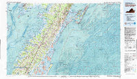
~ Chincoteague VA topo map, 1:100000 scale, 30 X 60 Minute, Historical, 1981, updated 1982
Chincoteague, Virginia, USGS topographic map dated 1981.
Includes geographic coordinates (latitude and longitude). This topographic map is suitable for hiking, camping, and exploring, or framing it as a wall map.
Printed on-demand using high resolution imagery, on heavy weight and acid free paper, or alternatively on a variety of synthetic materials.
Topos available on paper, Waterproof, Poly, or Tyvek. Usually shipping rolled, unless combined with other folded maps in one order.
- Product Number: USGS-5303634
- Free digital map download (high-resolution, GeoPDF): Chincoteague, Virginia (file size: 32 MB)
- Map Size: please refer to the dimensions of the GeoPDF map above
- Weight (paper map): ca. 55 grams
- Map Type: POD USGS Topographic Map
- Map Series: HTMC
- Map Verison: Historical
- Cell ID: 67291
- Scan ID: 188778
- Imprint Year: 1982
- Woodland Tint: Yes
- Aerial Photo Year: 1976
- Edit Year: 1981
- Datum: NAD27
- Map Projection: Universal Transverse Mercator
- Map published by United States Geological Survey
- Map Language: English
- Scanner Resolution: 600 dpi
- Map Cell Name: Chincoteague
- Grid size: 30 X 60 Minute
- Date on map: 1981
- Map Scale: 1:100000
- Geographical region: Virginia, United States
Neighboring Maps:
All neighboring USGS topo maps are available for sale online at a variety of scales.
Spatial coverage:
Topo map Chincoteague, Virginia, covers the geographical area associated the following places:
- Ticktown - Mutton Hunk - Mount Nebo - Jordan - Bloxom - Deep Hole - Bacon Hill - Smithville - Messongo - Pungoteague - Quinby - Painter - Modest Town - Grotons - Little Hell - Oak Hall - Allentown - Hopkins - Flag Pond Landing - Captains Cove - Wachapreague - Onancock - Hacksneck - Savage Town - Cedar View - Sanford - Tangier - Johnson Cove - Oakland Park - Tunnels Mill - Winterville - Howard (historical) - Lecato - Chincoteague - Pennyville - New Church - Davis Wharf - Coocheyville - Keller - Red Hill - Greenbush - Wattsville - Wishart - Tasley - Temperanceville - Peaceful Beach - Mappsburg - Middlesex - Chancetown - Metompkin - Locksville - Atlantic - Tyler - Wardtown - High Woods - Harborton - Bobtown - Indian Hammock - Shad Landing - Poulson - Whitesville - Macedonia - Black Point Landing - Justisville - Mears Station - Accomac - Locust Mount - Crockett Town - Sign Post - Groton Town - Daugherty Town - Nelsonia - Savageville - Parker Landing - East Point - Crisfield - Lawson - Peaceful Shores - Daugherty - Trower - Graysville - Melfa - Boston - Nandua - Pastoria - Woodland Park Mobile Home Park - Mappsville - Persimmon Point - Parksley - Shields - Mount Zion - Onley - Guilford - Willis Wharf - Parsonville - Highland Heights - Clam - Hadlock - Horsey - Belle Haven
- Map Area ID: AREA3837.5-76-75
- Northwest corner Lat/Long code: USGSNW38-76
- Northeast corner Lat/Long code: USGSNE38-75
- Southwest corner Lat/Long code: USGSSW37.5-76
- Southeast corner Lat/Long code: USGSSE37.5-75
- Northern map edge Latitude: 38
- Southern map edge Latitude: 37.5
- Western map edge Longitude: -76
- Eastern map edge Longitude: -75


