
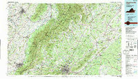
~ Charlottesville VA topo map, 1:100000 scale, 30 X 60 Minute, Historical, 1986, updated 1989
Charlottesville, Virginia, USGS topographic map dated 1986.
Includes geographic coordinates (latitude and longitude). This topographic map is suitable for hiking, camping, and exploring, or framing it as a wall map.
Printed on-demand using high resolution imagery, on heavy weight and acid free paper, or alternatively on a variety of synthetic materials.
Topos available on paper, Waterproof, Poly, or Tyvek. Usually shipping rolled, unless combined with other folded maps in one order.
- Product Number: USGS-5303632
- Free digital map download (high-resolution, GeoPDF): Charlottesville, Virginia (file size: 28 MB)
- Map Size: please refer to the dimensions of the GeoPDF map above
- Weight (paper map): ca. 55 grams
- Map Type: POD USGS Topographic Map
- Map Series: HTMC
- Map Verison: Historical
- Cell ID: 67275
- Scan ID: 188774
- Imprint Year: 1989
- Woodland Tint: Yes
- Visual Version Number: 2
- Aerial Photo Year: 1984
- Edit Year: 1986
- Datum: NAD27
- Map Projection: Universal Transverse Mercator
- Map published by United States Geological Survey
- Map Language: English
- Scanner Resolution: 600 dpi
- Map Cell Name: Charlottesville
- Grid size: 30 X 60 Minute
- Date on map: 1986
- Map Scale: 1:100000
- Geographical region: Virginia, United States
Neighboring Maps:
All neighboring USGS topo maps are available for sale online at a variety of scales.
Spatial coverage:
Topo map Charlottesville, Virginia, covers the geographical area associated the following places:
- Whipporwill Hollow - Cedarmere (historical) - Massanutten - Radiant - Liberty Mills - Lyndhurst - Belmont - Reynard Woods - Piedmont - Loftlands Wood - Wilhait - Yancey Mills - Stillfield - Fairgrove - Mountain Laurel - Dickensons Store - Shadwell - Tryme - Woodbrook - Commonwealth - Emerald Hills - Ruth - Oak Terrace - Ridgewood Mobile Home Park - Foxwood - Syria - Westover - Lakeside Mobile Home Park - Brinnington - Repton Mills - Rochelle - Burketown - Proffit - Oakpark - Shady Grove - Albano - Northfields - The Country Store - Mulberry Greens - Ivy Oaks - Springfield - Rapidan - Midway - Ivy - Pleasant Valley - Laurel Hill - Crossroads - Meriwether Hill - Northwoods Mobile Home Park - Inglewood - Windsor - Clearview Meadows - Village Square - Merrimac - Nasons - Trevilians - Montezuma - Duet - Wakefield - Paulington (historical) - Shifflet Corner - Uno - Kinderhook - Montevideo - Earlysville Heights - Berkmar - Dunlora Plantation - Westover Hills - Skyline Crest - Keswick - Friendship Heights - Everettsville - Hood - Sandy Bottom - Loch Leigh - Hinton - Lake Acres - Lindsay - Canterbury - Buena - Jollett - White Hall - Solsburg - Townwood - Squire Hill - Langford - Westmoreland - Lydia - Clarkson - Harrisonburg - Newtown - Dawsonville - Peacock Hill - Deerwood - Almond (historical) - Westover Hills - Pen Park - Larmond - Earlysville - Templeton Acres
- Map Area ID: AREA38.538-79-78
- Northwest corner Lat/Long code: USGSNW38.5-79
- Northeast corner Lat/Long code: USGSNE38.5-78
- Southwest corner Lat/Long code: USGSSW38-79
- Southeast corner Lat/Long code: USGSSE38-78
- Northern map edge Latitude: 38.5
- Southern map edge Latitude: 38
- Western map edge Longitude: -79
- Eastern map edge Longitude: -78


