
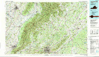
~ Charlottesville VA topo map, 1:100000 scale, 30 X 60 Minute, Historical, 1986, updated 1989
Charlottesville, Virginia, USGS topographic map dated 1986.
Includes geographic coordinates (latitude and longitude). This topographic map is suitable for hiking, camping, and exploring, or framing it as a wall map.
Printed on-demand using high resolution imagery, on heavy weight and acid free paper, or alternatively on a variety of synthetic materials.
Topos available on paper, Waterproof, Poly, or Tyvek. Usually shipping rolled, unless combined with other folded maps in one order.
- Product Number: USGS-5303628
- Free digital map download (high-resolution, GeoPDF): Charlottesville, Virginia (file size: 28 MB)
- Map Size: please refer to the dimensions of the GeoPDF map above
- Weight (paper map): ca. 55 grams
- Map Type: POD USGS Topographic Map
- Map Series: HTMC
- Map Verison: Historical
- Cell ID: 67275
- Scan ID: 188771
- Imprint Year: 1989
- Woodland Tint: Yes
- Visual Version Number: 1
- Aerial Photo Year: 1984
- Edit Year: 1986
- Datum: NAD27
- Map Projection: Universal Transverse Mercator
- Map published by United States Geological Survey
- Map Language: English
- Scanner Resolution: 600 dpi
- Map Cell Name: Charlottesville
- Grid size: 30 X 60 Minute
- Date on map: 1986
- Map Scale: 1:100000
- Geographical region: Virginia, United States
Neighboring Maps:
All neighboring USGS topo maps are available for sale online at a variety of scales.
Spatial coverage:
Topo map Charlottesville, Virginia, covers the geographical area associated the following places:
- Preston Heights - Ednam Forest - Shady Grove - Harriston - Country Green - Burtonville - Gordonsville - Midway - Thelma - Dawsons Shop (historical) - Meriwether Hill - Stonehenge - Greenfields - Laurel Hills - Birnam Wood - Clearview Meadows - West Woods - Scuffletown - Pantops - Elkton - Mill Run - Eheart - Beazley (historical) - Shadwell - Canterbury - Simmons Gap - Crozet - Hessian Hills - Brookwood - Haywood - Colthurst - Stony Point - Deer Run - Rosena - Mill Ridge - Townwood - Sullivan (historical) - Glenmore - Poindexter - Trevilians - Knightly - Haneytown - Weyers Cave - Decca (historical) - Fletcher - Westover Hills - Oakland - Northerly - Dawsonville - Vinegar Hill - Keswick - Whipporwill Hollow - Solsburg - Greenbriar Heights - Knollwood - Surprise - Little Clover Hill - Ivy Farms - Oak Hill - Berkmar - Lindsay - Mallard Lake - Waynesboro - Royal Acres - Ivy Woods - Mount Crawford - Monacan Town (historical) - Red Mills - Nasons - Duet - Meltons - Gilbert - Advance Mills Village - Ardwood - Elly - Lake Acres - Chinquapin - Aroda - Millington - Norwood - Orange - Watts - Cobham Park - Buena - Whiteshop Estates - Alderman Road Houses - Stemphleytown - Williams Fork - Repton Mills - Damtown - Lewis Hill East - Cutalong - Cismont - Stadium Road Residence Area - Camelot - Rotherwood - Dickensons Store - Mountfair - Upper Pocosin - Patterson Store
- Map Area ID: AREA38.538-79-78
- Northwest corner Lat/Long code: USGSNW38.5-79
- Northeast corner Lat/Long code: USGSNE38.5-78
- Southwest corner Lat/Long code: USGSSW38-79
- Southeast corner Lat/Long code: USGSSE38-78
- Northern map edge Latitude: 38.5
- Southern map edge Latitude: 38
- Western map edge Longitude: -79
- Eastern map edge Longitude: -78


