
~ Buena Vista VA topo map, 1:100000 scale, 30 X 60 Minute, Historical, 1986, updated 1986
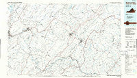
Buena Vista, Virginia, USGS topographic map dated 1986.
Includes geographic coordinates (latitude and longitude). This topographic map is suitable for hiking, camping, and exploring, or framing it as a wall map.
Printed on-demand using high resolution imagery, on heavy weight and acid free paper, or alternatively on a variety of synthetic materials.
Topos available on paper, Waterproof, Poly, or Tyvek. Usually shipping rolled, unless combined with other folded maps in one order.
- Product Number: USGS-5303626
- Free digital map download (high-resolution, GeoPDF): Buena Vista, Virginia (file size: 15 MB)
- Map Size: please refer to the dimensions of the GeoPDF map above
- Weight (paper map): ca. 55 grams
- Map Type: POD USGS Topographic Map
- Map Series: HTMC
- Map Verison: Historical
- Cell ID: 67194
- Scan ID: 188770
- Imprint Year: 1986
- Visual Version Number: 2
- Aerial Photo Year: 1984
- Edit Year: 1986
- Datum: NAD27
- Map Projection: Universal Transverse Mercator
- Planimetric: Yes
- Map published by United States Geological Survey
- Map Language: English
- Scanner Resolution: 600 dpi
- Map Cell Name: Buena Vista
- Grid size: 30 X 60 Minute
- Date on map: 1986
- Map Scale: 1:100000
- Geographical region: Virginia, United States
Neighboring Maps:
All neighboring USGS topo maps are available for sale online at a variety of scales.
Spatial coverage:
Topo map Buena Vista, Virginia, covers the geographical area associated the following places:
- Lignite - Millboro Springs - Gidsville - Maple Grove - Daggers Springs - Greenlee - Collierstown - Longwood (historical) - Wades Mill - Denmark - Falling Spring - Naola - Love - Rich Patch Mines - Mountain View - Comptons Bridge (historical) - Buchanan - Low Moor - South River - Snowden - Cedar Grove - Goshen - Five Forks - Brownsburg - Springfield - Natural Bridge Station - Midvale - Angelo - Kincaid - Glasgow - Buena Vista - Midway - Sardis - Blacksburg - Piney River - Parr - Clifton Forge - Haden - Perkins Point - Hot Springs - Union Hill - Hipes - Clifford - Buffalo Forge - Major - California - Woodson - Gilmore Mills - Wilkie (historical) - Forks of Buffalo - Sycamore Valley - Pedlar Mills - Wilson Springs - Buffalo Bend - Browntown - Mallow - Carloover - Alhambra - Riverside - Raphine - McNutt (historical) - Rich Patch - Sweet Briar Station - Pearch - Hooks Mill - Natural Bridge - Covington - Kerrs Creek - Lowesville - Murat - Nash - Enderly Heights - Balcony Falls - Greenwood (historical) - Davis - Mechanicsville - Surber - Greenwood - Massies Mill - Jonestown - Marlbrook - Timber Ridge - East Lexington - Tyro - Oronoco - Vesuvius - Longdale - Buffalo Hill - Agricola - Howell Mills - Healing Springs - Stewardsburg - Valley View - Mudtown - Montebello - Lexington - Pera - Fancy Hill - Coleman Falls - Big Island
- Map Area ID: AREA3837.5-80-79
- Northwest corner Lat/Long code: USGSNW38-80
- Northeast corner Lat/Long code: USGSNE38-79
- Southwest corner Lat/Long code: USGSSW37.5-80
- Southeast corner Lat/Long code: USGSSE37.5-79
- Northern map edge Latitude: 38
- Southern map edge Latitude: 37.5
- Western map edge Longitude: -80
- Eastern map edge Longitude: -79


