
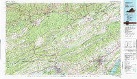
~ Bristol VA topo map, 1:100000 scale, 30 X 60 Minute, Historical, 1981, updated 1981
Bristol, Virginia, USGS topographic map dated 1981.
Includes geographic coordinates (latitude and longitude). This topographic map is suitable for hiking, camping, and exploring, or framing it as a wall map.
Printed on-demand using high resolution imagery, on heavy weight and acid free paper, or alternatively on a variety of synthetic materials.
Topos available on paper, Waterproof, Poly, or Tyvek. Usually shipping rolled, unless combined with other folded maps in one order.
- Product Number: USGS-5303622
- Free digital map download (high-resolution, GeoPDF): Bristol, Virginia (file size: 28 MB)
- Map Size: please refer to the dimensions of the GeoPDF map above
- Weight (paper map): ca. 55 grams
- Map Type: POD USGS Topographic Map
- Map Series: HTMC
- Map Verison: Historical
- Cell ID: 76783
- Scan ID: 188767
- Imprint Year: 1981
- Woodland Tint: Yes
- Visual Version Number: 1
- Aerial Photo Year: 1978
- Edit Year: 1981
- Datum: NAD27
- Map Projection: Universal Transverse Mercator
- Map published by Tennessee Valley Authority
- Map Language: English
- Scanner Resolution: 600 dpi
- Map Cell Name: Bristol
- Grid size: 30 X 60 Minute
- Date on map: 1981
- Map Scale: 1:100000
- Geographical region: Virginia, United States
Neighboring Maps:
All neighboring USGS topo maps are available for sale online at a variety of scales.
Spatial coverage:
Topo map Bristol, Virginia, covers the geographical area associated the following places:
- Ramsey - Kinkaid Estates - Addington - Benham - Carfax - Hansonville - Lynn Garden - McChesney Heights - Laurel - Carrico Mill - Arcadia - East Stone Gap - Cantrell (historical) - Snowflake - Virginia City - Beechwood (historical) - Gray Acres - Fleenors - Rocktown - Three Springs - Morrison City - Silica - Sugarville - Twin Springs - Fullers - Evergreen Hills - Vinegar Hill - Fair Acres - Bellamy - Withers - Tito - Johnson Court - Graystone Estates - Hemlock - Clear Creek (historical) - Westfield - Emmett - Derby - Akard Addition - Grays Ford - Tumbez - Holston Valley - Big Stone Gap - Beechcliff Estates - Greenfields - Oakleigh Estates - Windy Hill - Big Creek (historical) - Wininger - South Clinchfield - Leonardtown - Stone Bruise - Sac (historical) - Petlier (historical) - Ridgedale - Fraleytown - Anderson - Clinch - Collinwood - Pettyjohn Mill - Mew - Kermit - Harvey - Laurel Grove - Sevier Terrace - Corner - Yuma - Maytown - Manville - Horizon Hills - Springdale - Rock City - Bloomington Heights - Marshall Estates - Rotherwood Hills - Hill Country - Holiday Hills - Northcott - Wolfrun (historical) - Independence - Sunbright - Clover - Slabtown - Harper - Dwina - Roebuck - Huddle Mill - Artrip - Clutts - Herald - Ponderosa Estates - Oakview - Fleenor Spring - Evergreen - Kingsport - Highland Park - Jayne Mill - Maplehurst - Riverview - Blountville
- Map Area ID: AREA3736.5-83-82
- Northwest corner Lat/Long code: USGSNW37-83
- Northeast corner Lat/Long code: USGSNE37-82
- Southwest corner Lat/Long code: USGSSW36.5-83
- Southeast corner Lat/Long code: USGSSE36.5-82
- Northern map edge Latitude: 37
- Southern map edge Latitude: 36.5
- Western map edge Longitude: -83
- Eastern map edge Longitude: -82


