
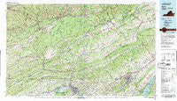
~ Bristol VA topo map, 1:100000 scale, 30 X 60 Minute, Historical, 1981, updated 1981
Bristol, Virginia, USGS topographic map dated 1981.
Includes geographic coordinates (latitude and longitude). This topographic map is suitable for hiking, camping, and exploring, or framing it as a wall map.
Printed on-demand using high resolution imagery, on heavy weight and acid free paper, or alternatively on a variety of synthetic materials.
Topos available on paper, Waterproof, Poly, or Tyvek. Usually shipping rolled, unless combined with other folded maps in one order.
- Product Number: USGS-5303620
- Free digital map download (high-resolution, GeoPDF): Bristol, Virginia (file size: 30 MB)
- Map Size: please refer to the dimensions of the GeoPDF map above
- Weight (paper map): ca. 55 grams
- Map Type: POD USGS Topographic Map
- Map Series: HTMC
- Map Verison: Historical
- Cell ID: 76783
- Scan ID: 188766
- Imprint Year: 1981
- Woodland Tint: Yes
- Visual Version Number: 2
- Aerial Photo Year: 1978
- Edit Year: 1981
- Datum: NAD27
- Map Projection: Universal Transverse Mercator
- Map published by Tennessee Valley Authority
- Map Language: English
- Scanner Resolution: 600 dpi
- Map Cell Name: Bristol
- Grid size: 30 X 60 Minute
- Date on map: 1981
- Map Scale: 1:100000
- Geographical region: Virginia, United States
Neighboring Maps:
All neighboring USGS topo maps are available for sale online at a variety of scales.
Spatial coverage:
Topo map Bristol, Virginia, covers the geographical area associated the following places:
- Nickelsville - Fox Run - Windmere - Coeburn - Herald - Greenland - Dorado - Sevier Terrace - Arno - West Ridge - Derby - Dorter Mill - Lone Star - Harrtown - Ridgedale - Weaver - Cross - Hansonville - Purcell - Sunbright - Vane (historical) - Mohawk (historical) - Vinegar Hill - Withers - Grizzle (historical) - Walnut Hill - Preston Hills - Mystic Valley - Westfield - Roda - Bruno - Vance - Grigbys Store - Avoca - Virginia City - Grays - Bellamy - Cumberland - Lynch - Bolton - Fair Acres - McConnell Mill - Riverview - Lano - Hazel - Seminary - Woodway - Indian Hills - Greenfields - Fulkerson - Bundy - Mew - Okolona - Rush Corner - Tennessee Hills - Big Stone Gap - Carfax - Lebanon - Candler - Flatwoods - Springfield Acres - Painter Spring - Petlier (historical) - Three Springs - Willow Springs - Briarwood - Newtown - Verdi - Masons Store (historical) - Carbo - Ely - Litz Manor - Brumley Gap - Cold Spring - Johnson Court - Belle Meadows - Cloud Ford - Church Hill - Valaho (historical) - Kingsport - Bush Mill - Fleenor Spring - Imboden - Sunny Brook - Mount Area Estates - Slabtown - Clinch - Wolfrun (historical) - Trammel (historical) - Horace (historical) - Cedar Grove - Point Truth - Saint Paul - Larkin Hills - Greendale - Arcadia - Lime Hill - Rock Hill Park - Duffield - Graystone Estates
- Map Area ID: AREA3736.5-83-82
- Northwest corner Lat/Long code: USGSNW37-83
- Northeast corner Lat/Long code: USGSNE37-82
- Southwest corner Lat/Long code: USGSSW36.5-83
- Southeast corner Lat/Long code: USGSSE36.5-82
- Northern map edge Latitude: 37
- Southern map edge Latitude: 36.5
- Western map edge Longitude: -83
- Eastern map edge Longitude: -82


