
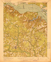
~ Surry VA topo map, 1:62500 scale, 15 X 15 Minute, Historical, 1919
Surry, Virginia, USGS topographic map dated 1919.
Includes geographic coordinates (latitude and longitude). This topographic map is suitable for hiking, camping, and exploring, or framing it as a wall map.
Printed on-demand using high resolution imagery, on heavy weight and acid free paper, or alternatively on a variety of synthetic materials.
Topos available on paper, Waterproof, Poly, or Tyvek. Usually shipping rolled, unless combined with other folded maps in one order.
- Product Number: USGS-5303470
- Free digital map download (high-resolution, GeoPDF): Surry, Virginia (file size: 8 MB)
- Map Size: please refer to the dimensions of the GeoPDF map above
- Weight (paper map): ca. 55 grams
- Map Type: POD USGS Topographic Map
- Map Series: HTMC
- Map Verison: Historical
- Cell ID: 63129
- Scan ID: 188630
- Woodland Tint: Yes
- Survey Year: 1917
- Datum: Unstated
- Map Projection: Unstated
- Map published by United States Army Corps of Engineers
- Map published by United States Department of War
- Map Language: English
- Scanner Resolution: 600 dpi
- Map Cell Name: Surry
- Grid size: 15 X 15 Minute
- Date on map: 1919
- Map Scale: 1:62500
- Geographical region: Virginia, United States
Neighboring Maps:
All neighboring USGS topo maps are available for sale online at a variety of scales.
Spatial coverage:
Topo map Surry, Virginia, covers the geographical area associated the following places:
- Spratleys Mill - Saint Georges Hundred - Ellis Fork - Gate House Farms - Tettington - Berrymans Corner - California Crossroads - Dendron - Earl Hall Mobile Home Park - Claremont - Newtown (historical) - Eastover - Runnymede - Lakewood - Pons - Delk Crossroads - First Colony - Mount Pleasant - Beachland - Moorings - Jamestown - Alliance - Surry - Spring Grove - Goodrich Fork - Elberon - Berkeleys Green - Pleasant Point - Scotland - Itata - Guilford Heights - Ingersoll (historical) - Powhatan Shores - Derrings Mill - Lazy Oak Corner - Claremont Manor - Blizzards Corners - Sunken Meadow Beach - Wakefield - Sexton (historical)
- Map Area ID: AREA37.2537-77-76.75
- Northwest corner Lat/Long code: USGSNW37.25-77
- Northeast corner Lat/Long code: USGSNE37.25-76.75
- Southwest corner Lat/Long code: USGSSW37-77
- Southeast corner Lat/Long code: USGSSE37-76.75
- Northern map edge Latitude: 37.25
- Southern map edge Latitude: 37
- Western map edge Longitude: -77
- Eastern map edge Longitude: -76.75


