
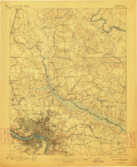
~ Richmond VA topo map, 1:62500 scale, 15 X 15 Minute, Historical, 1895, updated 1911
Richmond, Virginia, USGS topographic map dated 1895.
Includes geographic coordinates (latitude and longitude). This topographic map is suitable for hiking, camping, and exploring, or framing it as a wall map.
Printed on-demand using high resolution imagery, on heavy weight and acid free paper, or alternatively on a variety of synthetic materials.
Topos available on paper, Waterproof, Poly, or Tyvek. Usually shipping rolled, unless combined with other folded maps in one order.
- Product Number: USGS-5303342
- Free digital map download (high-resolution, GeoPDF): Richmond, Virginia (file size: 7 MB)
- Map Size: please refer to the dimensions of the GeoPDF map above
- Weight (paper map): ca. 55 grams
- Map Type: POD USGS Topographic Map
- Map Series: HTMC
- Map Verison: Historical
- Cell ID: 61604
- Scan ID: 188533
- Imprint Year: 1911
- Survey Year: 1892
- Datum: Unstated
- Map Projection: Unstated
- Map published by United States Geological Survey
- Map Language: English
- Scanner Resolution: 600 dpi
- Map Cell Name: Richmond
- Grid size: 15 X 15 Minute
- Date on map: 1895
- Map Scale: 1:62500
- Geographical region: Virginia, United States
Neighboring Maps:
All neighboring USGS topo maps are available for sale online at a variety of scales.
Spatial coverage:
Topo map Richmond, Virginia, covers the geographical area associated the following places:
- Northfield - Slash Cottage - Lewis Gardens - Oak Forest - Highland Springs - Windsor Place - Mattawan - New Cold Harbor - Walnut Grove - Rapidan Woods - Westover Hills - Fair Oaks - Sharon Park - Kirbytown - Locust Green - Gaines Mill - Eastover Gardens - Kingswood Court - Pine Heights - Middleton - Guilds Acres - Rainier Estates - Kosmo Village Mobile Home Park - Robin Ridge - Quail Walk - Windsor Farms - Cherrydale - Shannondale Estates - Gilbert Gardens - Cedar Lane - Laurel Park - Pine Hill - Brown Grove - Hilly Farms - Sandston - Church Hill - Lewistown - Fairlawn Heights - Cloverland - Virginia Heights - Spring Meadows - Kings Charter - Valley Oaks - Orchard Gardens - Elmont - Randolph Ridge - Lee Park - Swannanoa Estates - Stapleton - Studley Farms - Atlee Station - Mimosa Hills - Lydell Heights - Seven Pines - Woodland Park - Blue Star Estates - Acca - Atlee Ridge - Greenwood - East Highland Park - Brandy Creek Estates - Stonewall Estates - Chestnut Hill - Fieldshire - Burnside Farms - Atlee - Washington Park - Solomons Store - Strawhorn - Boudar - Forest Meadow Mobile Home Park - Laurel Grove Estates - Lower Rocketts - Hunton - Mechanicsville - Avondale - Peaks - Benthill - Fayette Park - Hundleys Corner - Battlefield Green - Brook Hill - Ginter Park - Knollwood - Church Hill - Dumbarton - Cold Harbor Farms - Central Gardens - The Colonies - French Hay - South Richmond - Hanover Heights South - Pottomoi - Pamunkey Estates - Manbur - Raven Run - Lincoln Park - Robinwood - Pole Green - Holly Ridge
- Map Area ID: AREA37.7537.5-77.5-77.25
- Northwest corner Lat/Long code: USGSNW37.75-77.5
- Northeast corner Lat/Long code: USGSNE37.75-77.25
- Southwest corner Lat/Long code: USGSSW37.5-77.5
- Southeast corner Lat/Long code: USGSSE37.5-77.25
- Northern map edge Latitude: 37.75
- Southern map edge Latitude: 37.5
- Western map edge Longitude: -77.5
- Eastern map edge Longitude: -77.25


