
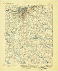
~ Petersburg VA topo map, 1:62500 scale, 15 X 15 Minute, Historical, 1894, updated 1945
Petersburg, Virginia, USGS topographic map dated 1894.
Includes geographic coordinates (latitude and longitude). This topographic map is suitable for hiking, camping, and exploring, or framing it as a wall map.
Printed on-demand using high resolution imagery, on heavy weight and acid free paper, or alternatively on a variety of synthetic materials.
Topos available on paper, Waterproof, Poly, or Tyvek. Usually shipping rolled, unless combined with other folded maps in one order.
- Product Number: USGS-5303266
- Free digital map download (high-resolution, GeoPDF): Petersburg, Virginia (file size: 7 MB)
- Map Size: please refer to the dimensions of the GeoPDF map above
- Weight (paper map): ca. 55 grams
- Map Type: POD USGS Topographic Map
- Map Series: HTMC
- Map Verison: Historical
- Cell ID: 60899
- Scan ID: 188457
- Imprint Year: 1945
- Survey Year: 1892
- Datum: Unstated
- Map Projection: Polyconic
- Map published by United States Geological Survey
- Map Language: English
- Scanner Resolution: 600 dpi
- Map Cell Name: Petersburg
- Grid size: 15 X 15 Minute
- Date on map: 1894
- Map Scale: 1:62500
- Geographical region: Virginia, United States
Neighboring Maps:
All neighboring USGS topo maps are available for sale online at a variety of scales.
Spatial coverage:
Topo map Petersburg, Virginia, covers the geographical area associated the following places:
- Bexley Trailer Park - Pocahontas - Ferndale Gardens - Berkeley Manor - Matoaca Manor - Oak Forest - Ettrick - Temple Estates - Mansfield - Battlefield Park - Friend (historical) - Kennelworth - Battersea - Forest Acres - Blandford - River View Park - Oak Shades Mobile Home Park - Southern Pines - Reams - Petersburg - Oakhurst - Lakewood - Olympic Mobile Home Park - College Park - Noweta Gardens - Virginia Hills - Carson - Colonial Heights - Matoaca - Pembroke - Dunedin - River Road Estates - Southern Estates - Ramblewood - Parkview - Westover Park - Western Hills - Reeves (historical) - Country Aire Mobile Home Park - Camelot - Templeton - Pine Gardens - Timberly Heights - Hickory Hill Estates - Warrington Heights - Prince George - Ethridge Estates - Spring Garden Mobile Home Park - Pine Ridge Mobile Home Court - Greenwood Farms - Walnut Hill - Beechnut Acres - Bollinger Estates - Maitland Village - Trojan Woods - Ferndale Park - Lakemont - Talpa (historical) - River Road Terrace - Hickory Hill Mobile Home Park - West Chesterfield Heights - Coddyshore (historical) - Wedgewood Farms - Westbourne - Lees Mill - New Bohemia - West Petersburg - Holly Acres - Rabbit Run - Youngblood Acres - Woodmere - Edge Hill Park - Heights - Robertson Place - Walnut Hill Gardens - Oakhill - Academy (historical) - Westchester - Duck Woods - Rohoic Farms - Franklin Farms - Burnside - Kingwood - Dinwiddie Gardens - Wildwood Farms - Flactem Manor - Grant Village - Sysonby Ridge - Rowanta - Ashley - Derby (historical)
- Map Area ID: AREA37.2537-77.5-77.25
- Northwest corner Lat/Long code: USGSNW37.25-77.5
- Northeast corner Lat/Long code: USGSNE37.25-77.25
- Southwest corner Lat/Long code: USGSSW37-77.5
- Southeast corner Lat/Long code: USGSSE37-77.25
- Northern map edge Latitude: 37.25
- Southern map edge Latitude: 37
- Western map edge Longitude: -77.5
- Eastern map edge Longitude: -77.25


