
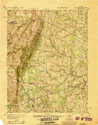
~ Middleburg VA topo map, 1:62500 scale, 15 X 15 Minute, Historical, 1933
Middleburg, Virginia, USGS topographic map dated 1933.
Includes geographic coordinates (latitude and longitude). This topographic map is suitable for hiking, camping, and exploring, or framing it as a wall map.
Printed on-demand using high resolution imagery, on heavy weight and acid free paper, or alternatively on a variety of synthetic materials.
Topos available on paper, Waterproof, Poly, or Tyvek. Usually shipping rolled, unless combined with other folded maps in one order.
- Product Number: USGS-5303110
- Free digital map download (high-resolution, GeoPDF): Middleburg, Virginia (file size: 9 MB)
- Map Size: please refer to the dimensions of the GeoPDF map above
- Weight (paper map): ca. 55 grams
- Map Type: POD USGS Topographic Map
- Map Series: HTMC
- Map Verison: Historical
- Cell ID: 57592
- Scan ID: 188348
- Woodland Tint: Yes
- Edit Year: 1943
- Datum: NAD
- Map Projection: Polyconic
- Map published by United States Army Corps of Engineers
- Map published by United States Army
- Map Language: English
- Scanner Resolution: 600 dpi
- Map Cell Name: Middleburg
- Grid size: 15 X 15 Minute
- Date on map: 1933
- Map Scale: 1:62500
- Geographical region: Virginia, United States
Neighboring Maps:
All neighboring USGS topo maps are available for sale online at a variety of scales.
Spatial coverage:
Topo map Middleburg, Virginia, covers the geographical area associated the following places:
- Sunny Bank (historical) - Boxwood Farms - New Baltimore - Carlyle Station - Old Field Estates - Olde South Estates - New Market - Crestwood Village - Bull Run - Little Georgetown - Breezy Knolls Estates - Rocky Run - Waterfall - Kennard Ridge - Catharpin Farms Estates - Haymarket - Groveton - Levy - Rixlew - Buckland - Lawnvale Estates - German - Watson - Dover - Conklin - Catharpin - Country Scene - Forest Hills Estates - Westgate - Evergreen Farms - Hopewell - Hickory Grove Acres - Halfway - Waterfall Village - Browns Corner - Brambleton - Mountain View Estates - South Riding - Sudley Springs - Stepney Plantation - New Hope Forest - Twin Oaks - Stoke - Sudley Mountain Estates - Butler - Pilgrims Rest - Knollwood Estates - Forest Lake Estates - Burke Meadows - Bushy Acres - Coverstone - Zouave Hills - Aldie - Beverley Mill - Gilberts Corner - Gypsum Hill Estates - Wellington - Antioch - Snow Hill - Arcola - Gainesville - Broad Run Village - Broad Run - Swansen - Catharpin Farms - Royville - Bull Run East - Bowmantown - Burns Crossroads - Skinkertown - Stewartown - Crescent - Linton Hall - Lakeview Estates - Hutchinson - Woolsey - Landmark - Iron Gate - Mill Creek Estates - Lakeview - Hickory Grove - Middleburg - Long Level Estates - Hillwood Park Mobile Home Park - Tara Wood - Broken Hill - Bull Run Mountain Estates - Cedar Knolls - Ashton Glen - Lenah - Bannerwood - Bataan Village
- Map Area ID: AREA3938.75-77.75-77.5
- Northwest corner Lat/Long code: USGSNW39-77.75
- Northeast corner Lat/Long code: USGSNE39-77.5
- Southwest corner Lat/Long code: USGSSW38.75-77.75
- Southeast corner Lat/Long code: USGSSE38.75-77.5
- Northern map edge Latitude: 39
- Southern map edge Latitude: 38.75
- Western map edge Longitude: -77.75
- Eastern map edge Longitude: -77.5


