
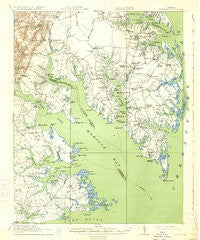
~ Mathews VA topo map, 1:62500 scale, 15 X 15 Minute, Historical, 1917, updated 1934
Mathews, Virginia, USGS topographic map dated 1917.
Includes geographic coordinates (latitude and longitude). This topographic map is suitable for hiking, camping, and exploring, or framing it as a wall map.
Printed on-demand using high resolution imagery, on heavy weight and acid free paper, or alternatively on a variety of synthetic materials.
Topos available on paper, Waterproof, Poly, or Tyvek. Usually shipping rolled, unless combined with other folded maps in one order.
- Product Number: USGS-5303084
- Free digital map download (high-resolution, GeoPDF): Mathews, Virginia (file size: 6 MB)
- Map Size: please refer to the dimensions of the GeoPDF map above
- Weight (paper map): ca. 55 grams
- Map Type: POD USGS Topographic Map
- Map Series: HTMC
- Map Verison: Historical
- Cell ID: 57267
- Scan ID: 188316
- Imprint Year: 1934
- Survey Year: 1916
- Datum: NAD
- Map Projection: Polyconic
- Map published by United States Army Corps of Engineers
- Map published by United States Department of War
- Map Language: English
- Scanner Resolution: 600 dpi
- Map Cell Name: Mathews
- Grid size: 15 X 15 Minute
- Date on map: 1917
- Map Scale: 1:62500
- Geographical region: Virginia, United States
Neighboring Maps:
All neighboring USGS topo maps are available for sale online at a variety of scales.
Spatial coverage:
Topo map Mathews, Virginia, covers the geographical area associated the following places:
- Peary - Redart - Fort Nonsense - Elmington - Oyster Cove - Cardinal - Haven Beach - Severn Manor - Foster - Dixondale (historical) - Moon - Blakes - Ware Neck - Selden - Bena - Beaverlett - Rowes Haven - Perrin - Glen Roy Estates - Marshall Heights - Severn - Brays Landing - Bohannon - Motorun - Maryus - Diggs - Dutton - Port Haywood - Bavon - Victory Hill - Blackwater - Retz - Gloucester Point - Tabernacle - Soles - New Point - Ruff - Baileys - Mathews - Mill Creek - Waterview Mobile Home Park - Lands End - York River Farms - Hudgins - Naxera - Point Lookout - Crab - Susan - Schley - Mobjack - Williams - Hallieford - Onemo - Cricket Hill - Rosemont - Zanoni - Sarah - Fitchetts - Haven (historical) - Pribble - Laban - Hockley - Quiet Cove - Shadow - Winter Harbor Haven - Nuttall - Achilles - Tidemill - Broad Marsh - Beulah - Bayside
- Map Area ID: AREA37.537.25-76.5-76.25
- Northwest corner Lat/Long code: USGSNW37.5-76.5
- Northeast corner Lat/Long code: USGSNE37.5-76.25
- Southwest corner Lat/Long code: USGSSW37.25-76.5
- Southeast corner Lat/Long code: USGSSE37.25-76.25
- Northern map edge Latitude: 37.5
- Southern map edge Latitude: 37.25
- Western map edge Longitude: -76.5
- Eastern map edge Longitude: -76.25


