
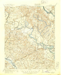
~ King William VA topo map, 1:62500 scale, 15 X 15 Minute, Historical, 1920, updated 1944
King William, Virginia, USGS topographic map dated 1920.
Includes geographic coordinates (latitude and longitude). This topographic map is suitable for hiking, camping, and exploring, or framing it as a wall map.
Printed on-demand using high resolution imagery, on heavy weight and acid free paper, or alternatively on a variety of synthetic materials.
Topos available on paper, Waterproof, Poly, or Tyvek. Usually shipping rolled, unless combined with other folded maps in one order.
- Product Number: USGS-5303004
- Free digital map download (high-resolution, GeoPDF): King William, Virginia (file size: 8 MB)
- Map Size: please refer to the dimensions of the GeoPDF map above
- Weight (paper map): ca. 55 grams
- Map Type: POD USGS Topographic Map
- Map Series: HTMC
- Map Verison: Historical
- Cell ID: 56199
- Scan ID: 188250
- Imprint Year: 1944
- Survey Year: 1918
- Datum: Unstated
- Map Projection: Polyconic
- Map published by United States Army Corps of Engineers
- Map published by United States Department of War
- Map Language: English
- Scanner Resolution: 600 dpi
- Map Cell Name: King William
- Grid size: 15 X 15 Minute
- Date on map: 1920
- Map Scale: 1:62500
- Geographical region: Virginia, United States
Neighboring Maps:
All neighboring USGS topo maps are available for sale online at a variety of scales.
Spatial coverage:
Topo map King William, Virginia, covers the geographical area associated the following places:
- Alexanders Corner - Crumps Mill - Windsor - Horseshoe - Manquin - Central Garage - Tunstall - Hanovertown - Quinton - Eastern View - Wicker Corner - Liggans Corner - Glimpses Corner - Whites (historical) - Holts Corner - Poplar Grove - Currituck Farms - Hampstead - Locust Grove - Green Meadows - Tallysville - Old Cannon Estates - Carps Corner - Cant (historical) - Westwood - Appersons Store - Woodlawn - Browns Corner - Whitebank - Dispatch (historical) - Putneys Mill - Old Church - Elsing Green - Northbury - Orapax Farms - Walkerton - King William - Enfield - Chericoke - Woodview Hills - Five Lakes Subdivision - Richardson (historical) - Sinclair Manor - Farmers Shop Corner - Rumford - Whitehall - Waterloo - Pine Knoll - Bradley Acres - Pamunkey (historical)
- Map Area ID: AREA37.7537.5-77.25-77
- Northwest corner Lat/Long code: USGSNW37.75-77.25
- Northeast corner Lat/Long code: USGSNE37.75-77
- Southwest corner Lat/Long code: USGSSW37.5-77.25
- Southeast corner Lat/Long code: USGSSE37.5-77
- Northern map edge Latitude: 37.75
- Southern map edge Latitude: 37.5
- Western map edge Longitude: -77.25
- Eastern map edge Longitude: -77


