
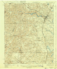
~ Emporia VA topo map, 1:62500 scale, 15 X 15 Minute, Historical, 1919, updated 1943
Emporia, Virginia, USGS topographic map dated 1919.
Includes geographic coordinates (latitude and longitude). This topographic map is suitable for hiking, camping, and exploring, or framing it as a wall map.
Printed on-demand using high resolution imagery, on heavy weight and acid free paper, or alternatively on a variety of synthetic materials.
Topos available on paper, Waterproof, Poly, or Tyvek. Usually shipping rolled, unless combined with other folded maps in one order.
- Product Number: USGS-5302864
- Free digital map download (high-resolution, GeoPDF): Emporia, Virginia (file size: 9 MB)
- Map Size: please refer to the dimensions of the GeoPDF map above
- Weight (paper map): ca. 55 grams
- Map Type: POD USGS Topographic Map
- Map Series: HTMC
- Map Verison: Historical
- Cell ID: 53903
- Scan ID: 188095
- Imprint Year: 1943
- Survey Year: 1918
- Datum: NAD
- Map Projection: Polyconic
- Map published by United States Geological Survey
- Map Language: English
- Scanner Resolution: 600 dpi
- Map Cell Name: Emporia
- Grid size: 15 X 15 Minute
- Date on map: 1919
- Map Scale: 1:62500
- Geographical region: Virginia, United States
Neighboring Maps:
All neighboring USGS topo maps are available for sale online at a variety of scales.
Spatial coverage:
Topo map Emporia, Virginia, covers the geographical area associated the following places:
- Lincoln Heights - Durand - Skippers - Gum Forks - Dons Mobile Home Park - Walnut Heights - Pleasant Hill - Ante - Radium - Racume - North Emporia - Greenwood Park - Pine View Mobile Home Park - Gaston - Bufford Crossroads - Magnums Mobile Home Park - Lanes Corner - Slates Corner - Lakeside Village Mobile Home Park - White City - Moonlight - Totaro - Paris Store - Webbs Mill - Emporia - Brewers Crossroads - Kingsberry - Barley - Brink - Dahlia - Harris Crossroads - Halifax Manor Mobile Home Park - Garners Mill - Mitchells Mill - Turners Crossroads - Westover Hills - Stancell - Washington Park
- Map Area ID: AREA36.7536.5-77.75-77.5
- Northwest corner Lat/Long code: USGSNW36.75-77.75
- Northeast corner Lat/Long code: USGSNE36.75-77.5
- Southwest corner Lat/Long code: USGSSW36.5-77.75
- Southeast corner Lat/Long code: USGSSE36.5-77.5
- Northern map edge Latitude: 36.75
- Southern map edge Latitude: 36.5
- Western map edge Longitude: -77.75
- Eastern map edge Longitude: -77.5


