
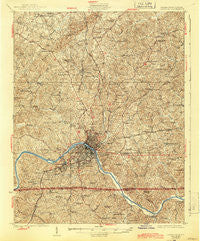
~ Danville VA topo map, 1:62500 scale, 15 X 15 Minute, Historical, 1925, updated 1944
Danville, Virginia, USGS topographic map dated 1925.
Includes geographic coordinates (latitude and longitude). This topographic map is suitable for hiking, camping, and exploring, or framing it as a wall map.
Printed on-demand using high resolution imagery, on heavy weight and acid free paper, or alternatively on a variety of synthetic materials.
Topos available on paper, Waterproof, Poly, or Tyvek. Usually shipping rolled, unless combined with other folded maps in one order.
- Product Number: USGS-5302790
- Free digital map download (high-resolution, GeoPDF): Danville, Virginia (file size: 11 MB)
- Map Size: please refer to the dimensions of the GeoPDF map above
- Weight (paper map): ca. 55 grams
- Map Type: POD USGS Topographic Map
- Map Series: HTMC
- Map Verison: Historical
- Cell ID: 53205
- Scan ID: 188035
- Imprint Year: 1944
- Survey Year: 1923
- Datum: NAD
- Map Projection: Polyconic
- Map published by United States Geological Survey
- Map Language: English
- Scanner Resolution: 600 dpi
- Map Cell Name: Danville
- Grid size: 15 X 15 Minute
- Date on map: 1925
- Map Scale: 1:62500
- Geographical region: Virginia, United States
Neighboring Maps:
All neighboring USGS topo maps are available for sale online at a variety of scales.
Spatial coverage:
Topo map Danville, Virginia, covers the geographical area associated the following places:
- Shelton - Donna Estates - Gatewood - Robinwood - Stokesland - Seminole Hills - Danville Estates - Whitetown - Cartersville - Woodbury Hills - Country Club West - Dan River (historical) - Pleasant Grove - Mountain Hill - Ridgecrest - Edgewood - Temple Terrace - Sherwood Forest - Rutledge Creek Park - Virginia Hills - New Design - Laniers Mill - Forest Hills - Birnam Wood - Surry Hills - Beverly Park - Pine Crest - Starmount Forest - Oak Hills - Windsor Heights - Whiteoak (historical) - Lakewood - Hopewell - Blanch - Major Court - Pleasant Gap - Shadowwood Park - Keeling - Fairfield Park - Beaver Park - Almagro - Beverstone Park - Springfield - Witt - Westover Hills - Wedgewood - Glenwood - Ringgold - New Mount Cross - Providence - Afton Hills - Fox Hollow - Miller Park - Cedar Park - Pelham - Dundee - Wyndover Woods - Swain Acres - Green Acres - Mount Hermon - Mount Cross - Withers Park - Danville - Olde Hunting Hills - Whitfield - Norwood Park - Chatham Hills - Druid Hills - Grove Park - Brentwood Park - Blairs - Schoolfield - Tanglewydle - Kentuck - Woodlake Park - Lumpkin Forest - Sandy Shores - Wallace Mill - Northbrook Park - Newton - Pinetag
- Map Area ID: AREA36.7536.5-79.5-79.25
- Northwest corner Lat/Long code: USGSNW36.75-79.5
- Northeast corner Lat/Long code: USGSNE36.75-79.25
- Southwest corner Lat/Long code: USGSSW36.5-79.5
- Southeast corner Lat/Long code: USGSSE36.5-79.25
- Northern map edge Latitude: 36.75
- Southern map edge Latitude: 36.5
- Western map edge Longitude: -79.5
- Eastern map edge Longitude: -79.25


