
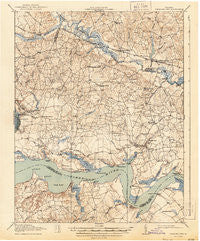
~ Charles City VA topo map, 1:62500 scale, 15 X 15 Minute, Historical, 1918, updated 1944
Charles City, Virginia, USGS topographic map dated 1918.
Includes geographic coordinates (latitude and longitude). This topographic map is suitable for hiking, camping, and exploring, or framing it as a wall map.
Printed on-demand using high resolution imagery, on heavy weight and acid free paper, or alternatively on a variety of synthetic materials.
Topos available on paper, Waterproof, Poly, or Tyvek. Usually shipping rolled, unless combined with other folded maps in one order.
- Product Number: USGS-5302690
- Free digital map download (high-resolution, GeoPDF): Charles City, Virginia (file size: 7 MB)
- Map Size: please refer to the dimensions of the GeoPDF map above
- Weight (paper map): ca. 55 grams
- Map Type: POD USGS Topographic Map
- Map Series: HTMC
- Map Verison: Historical
- Cell ID: 52414
- Scan ID: 187945
- Imprint Year: 1944
- Visual Version Number: 1
- Survey Year: 1917
- Datum: NAD
- Map Projection: Polyconic
- Map published by United States Army Corps of Engineers
- Map published by United States Department of War
- Map Language: English
- Scanner Resolution: 600 dpi
- Map Cell Name: Charles City
- Grid size: 15 X 15 Minute
- Date on map: 1918
- Map Scale: 1:62500
- Geographical region: Virginia, United States
Neighboring Maps:
All neighboring USGS topo maps are available for sale online at a variety of scales.
Spatial coverage:
Topo map Charles City, Virginia, covers the geographical area associated the following places:
- Mountcastle - Beechwood Manor - Charles City - Upper Brandon - Dunnmore - Nance - Weyanoke - Kimages - Glendale - Freetown (historical) - Blairs - Ednas Mill - Barnetts - Ruthville - Wrights Corner - Woodhaven Shores - Milton - Merchants Hope (historical) - Sherwood Forest - Willow Hill - Granville - Rolands Mill - Westover - Fort Powhatan - Elko - Berkeley - Sandybottom - Rivers Edge - Jordan Point Manor - Wayside - New Hope - Providence Forge - Haxall - Beechwood - Montpelier - Roxbury - Greenway - Beaver Castle Mobile Home Park - Roaches Corner - Jordans Point (historical)
- Map Area ID: AREA37.537.25-77.25-77
- Northwest corner Lat/Long code: USGSNW37.5-77.25
- Northeast corner Lat/Long code: USGSNE37.5-77
- Southwest corner Lat/Long code: USGSSW37.25-77.25
- Southeast corner Lat/Long code: USGSSE37.25-77
- Northern map edge Latitude: 37.5
- Southern map edge Latitude: 37.25
- Western map edge Longitude: -77.25
- Eastern map edge Longitude: -77


