
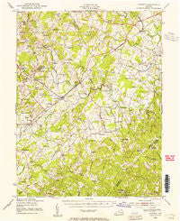
~ Catlett VA topo map, 1:62500 scale, 15 X 15 Minute, Historical, 1943, updated 1955
Catlett, Virginia, USGS topographic map dated 1943.
Includes geographic coordinates (latitude and longitude). This topographic map is suitable for hiking, camping, and exploring, or framing it as a wall map.
Printed on-demand using high resolution imagery, on heavy weight and acid free paper, or alternatively on a variety of synthetic materials.
Topos available on paper, Waterproof, Poly, or Tyvek. Usually shipping rolled, unless combined with other folded maps in one order.
- Product Number: USGS-5302680
- Free digital map download (high-resolution, GeoPDF): Catlett, Virginia (file size: 7 MB)
- Map Size: please refer to the dimensions of the GeoPDF map above
- Weight (paper map): ca. 55 grams
- Map Type: POD USGS Topographic Map
- Map Series: HTMC
- Map Verison: Historical
- Cell ID: 52278
- Scan ID: 187935
- Imprint Year: 1955
- Woodland Tint: Yes
- Edit Year: 1943
- Survey Year: 1926
- Datum: NAD27
- Map Projection: Polyconic
- Map published by United States Army Corps of Engineers
- Map Language: English
- Scanner Resolution: 600 dpi
- Map Cell Name: Catlett
- Grid size: 15 X 15 Minute
- Date on map: 1943
- Map Scale: 1:62500
- Geographical region: Virginia, United States
Neighboring Maps:
All neighboring USGS topo maps are available for sale online at a variety of scales.
Spatial coverage:
Topo map Catlett, Virginia, covers the geographical area associated the following places:
- Midland - Stafford Station - Weaversville - Eustacestown - Aden - Greenwich - Blackwell Town - Kings Crossroads - Oxfordshire - Greenville - Oak Tree Corner - Crossroads - Cromwell - Ruby - Eustaces Corner - Millbrook - Weimertown - Lake Arrowhead - Morgansburg - Germantown - Brent Turf Acres - Elk Run - Auburn - Calverton - Casanova - King Richard Estates - Woodlawn Farms - Mountainview - Rolling Hills - Balls Mill - Shiloh - Somerville - Rock Hill Estates - Walnut Ridge - Daniels Mill - Bristow - Greenwich Acres - Morrisville - Colvin Farms - Brent Town - Walnut Ridge Estates - Bristersburg - Aquia Creek Estates - Sowego - Lois - Yocum - Rock Hill Manors - Turkey Run - Bleak - Saint Stephens - Catlett - Nokesville - Colonial Acres - Tacketts Mill - Davids Crossroads - Clover Hill
- Map Area ID: AREA38.7538.5-77.75-77.5
- Northwest corner Lat/Long code: USGSNW38.75-77.75
- Northeast corner Lat/Long code: USGSNE38.75-77.5
- Southwest corner Lat/Long code: USGSSW38.5-77.75
- Southeast corner Lat/Long code: USGSSE38.5-77.5
- Northern map edge Latitude: 38.75
- Southern map edge Latitude: 38.5
- Western map edge Longitude: -77.75
- Eastern map edge Longitude: -77.5


