
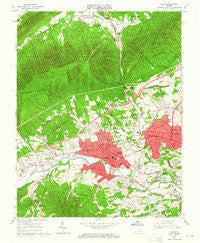
~ Salem VA topo map, 1:24000 scale, 7.5 X 7.5 Minute, Historical, 1963, updated 1965
Salem, Virginia, USGS topographic map dated 1963.
Includes geographic coordinates (latitude and longitude). This topographic map is suitable for hiking, camping, and exploring, or framing it as a wall map.
Printed on-demand using high resolution imagery, on heavy weight and acid free paper, or alternatively on a variety of synthetic materials.
Topos available on paper, Waterproof, Poly, or Tyvek. Usually shipping rolled, unless combined with other folded maps in one order.
- Product Number: USGS-5300900
- Free digital map download (high-resolution, GeoPDF): Salem, Virginia (file size: 14 MB)
- Map Size: please refer to the dimensions of the GeoPDF map above
- Weight (paper map): ca. 55 grams
- Map Type: POD USGS Topographic Map
- Map Series: HTMC
- Map Verison: Historical
- Cell ID: 39424
- Scan ID: 186606
- Imprint Year: 1965
- Woodland Tint: Yes
- Aerial Photo Year: 1960
- Field Check Year: 1963
- Datum: NAD27
- Map Projection: Polyconic
- Map published by United States Geological Survey
- Map Language: English
- Scanner Resolution: 600 dpi
- Map Cell Name: Salem
- Grid size: 7.5 X 7.5 Minute
- Date on map: 1963
- Map Scale: 1:24000
- Geographical region: Virginia, United States
Neighboring Maps:
All neighboring USGS topo maps are available for sale online at a variety of scales.
Spatial coverage:
Topo map Salem, Virginia, covers the geographical area associated the following places:
- Locust Grove Park - Hillcrest Heights - Riverland Court - Heidelberg Estates - Mountain Heights - Lee Hy Park - Rolling Hills - Pine Oak Heights - Mitchell - Spangler - Oak Ridge - Honeysuckle Bluff - Loch Haven - Hill Subdivision - Wedgewood Forest - Blue Ridge Park - Park Place - Skyview - West View Terrace - Moneiro - Circle Terrace - Whitefield - Mountain View - Palmer Park - Sunset Village - Lake View - Salem - Woodlawn - Meadow Wood Estates - Palmer - Wilmont Park - Windsor Court - Stonewall Forest - Boulevard Estates - Hemlock Hills - Westfield - Grandview - Edgewood - King - Wilmont Farms - Forest Lawn - Mountain Brook Estates - Mount Regis Heights - Orchard Heights - Monticello Estates - Norwood - Kerner - Vermont Heights - Dawnwood Forest - South Edgewood - Beacon Hills - Stratford Park - Riverside Estates - West Park - Mountain Heights East - Hanging Rock - Lewis Place - Plainview - Westland - Washington Heights - Spruce Hill - Lake Spring - Willow Green - Ridgewood Park - Dixie Heights - Shamrock - Cherry Hill Park - Braxton Heights - Hickory Hill - Evans Hill - Bonvue Heights - Ridgewood Farm - Woodside Park - Windsor Hills - Oak Park - Fairway Forest - Deep Dell - Woodbridge - Lawndale Heights - Fairfield - Oak Grove Farms - Edgewood - Edgelawn - Westchester Court - Southdowns - Medmont Lake - Knollwood - Carlton Park - Spring Garden - Huddleston Court - Beverly Heights North - Cameron Court - Homeplace - Medley - Green Hill Terrace - Moomaw Heights - Bellevue Park - Pine Grove - Karen Hills - Langhorne Place
- Map Area ID: AREA37.37537.25-80.125-80
- Northwest corner Lat/Long code: USGSNW37.375-80.125
- Northeast corner Lat/Long code: USGSNE37.375-80
- Southwest corner Lat/Long code: USGSSW37.25-80.125
- Southeast corner Lat/Long code: USGSSE37.25-80
- Northern map edge Latitude: 37.375
- Southern map edge Latitude: 37.25
- Western map edge Longitude: -80.125
- Eastern map edge Longitude: -80


