
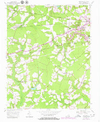
~ Buckhorn VA topo map, 1:24000 scale, 7.5 X 7.5 Minute, Historical, 1954, updated 1980
Buckhorn, Virginia, USGS topographic map dated 1954.
Includes geographic coordinates (latitude and longitude). This topographic map is suitable for hiking, camping, and exploring, or framing it as a wall map.
Printed on-demand using high resolution imagery, on heavy weight and acid free paper, or alternatively on a variety of synthetic materials.
Topos available on paper, Waterproof, Poly, or Tyvek. Usually shipping rolled, unless combined with other folded maps in one order.
- Product Number: USGS-5296881
- Free digital map download (high-resolution, GeoPDF): Buckhorn, Virginia (file size: 9 MB)
- Map Size: please refer to the dimensions of the GeoPDF map above
- Weight (paper map): ca. 55 grams
- Map Type: POD USGS Topographic Map
- Map Series: HTMC
- Map Verison: Historical
- Cell ID: 5920
- Scan ID: 184292
- Imprint Year: 1980
- Woodland Tint: Yes
- Photo Revision Year: 1979
- Aerial Photo Year: 1978
- Edit Year: 1979
- Survey Year: 1954
- Datum: NAD27
- Map Projection: Polyconic
- Map published by United States Geological Survey
- Map Language: English
- Scanner Resolution: 600 dpi
- Map Cell Name: Buckhorn
- Grid size: 7.5 X 7.5 Minute
- Date on map: 1954
- Map Scale: 1:24000
- Geographical region: Virginia, United States
Neighboring Maps:
All neighboring USGS topo maps are available for sale online at a variety of scales.
Spatial coverage:
Topo map Buckhorn, Virginia, covers the geographical area associated the following places:
- Lutersville - Manning - Lakewood - Bethlehem Terrace - Kenyon - Pinaire - Bethlehem Court - Lummis - Lake Speight Colony - Oak Ridge Estates - Leesville - Kilby - Nurneysville - Oak Ridge - Box Elder - Westgate - Bakers Crossing - Barrett Acres - Maple Hill - Oak Ridge East - Hillsdale - Forest Glen Terrace
- Map Area ID: AREA36.7536.625-76.75-76.625
- Northwest corner Lat/Long code: USGSNW36.75-76.75
- Northeast corner Lat/Long code: USGSNE36.75-76.625
- Southwest corner Lat/Long code: USGSSW36.625-76.75
- Southeast corner Lat/Long code: USGSSE36.625-76.625
- Northern map edge Latitude: 36.75
- Southern map edge Latitude: 36.625
- Western map edge Longitude: -76.75
- Eastern map edge Longitude: -76.625


