
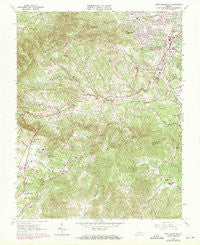
~ Bent Mountain VA topo map, 1:24000 scale, 7.5 X 7.5 Minute, Historical, 1963, updated 1971
Bent Mountain, Virginia, USGS topographic map dated 1963.
Includes geographic coordinates (latitude and longitude). This topographic map is suitable for hiking, camping, and exploring, or framing it as a wall map.
Printed on-demand using high resolution imagery, on heavy weight and acid free paper, or alternatively on a variety of synthetic materials.
Topos available on paper, Waterproof, Poly, or Tyvek. Usually shipping rolled, unless combined with other folded maps in one order.
- Product Number: USGS-5296507
- Free digital map download (high-resolution, GeoPDF): Bent Mountain, Virginia (file size: 16 MB)
- Map Size: please refer to the dimensions of the GeoPDF map above
- Weight (paper map): ca. 55 grams
- Map Type: POD USGS Topographic Map
- Map Series: HTMC
- Map Verison: Historical
- Cell ID: 3371
- Scan ID: 184079
- Imprint Year: 1971
- Woodland Tint: Yes
- Photo Revision Year: 1970
- Aerial Photo Year: 1970
- Field Check Year: 1963
- Datum: NAD27
- Map Projection: Polyconic
- Map published by United States Geological Survey
- Map Language: English
- Scanner Resolution: 600 dpi
- Map Cell Name: Bent Mountain
- Grid size: 7.5 X 7.5 Minute
- Date on map: 1963
- Map Scale: 1:24000
- Geographical region: Virginia, United States
Neighboring Maps:
All neighboring USGS topo maps are available for sale online at a variety of scales.
Spatial coverage:
Topo map Bent Mountain, Virginia, covers the geographical area associated the following places:
- Highfields Farm Estates - Crestwood - Manwaring Manor - Homewood - Kings Forest - Poages Mill Estates - Scenic Hills - Rosecrest - Bridlewood - Sugar Loaf Estates - Laurel Hills - Wyndale - Southwoods - Lynn Dell Estates - Windsor Estates - Farris Heights - Falcon Ridge Estates - Nottingham Heights - Briar Ridge - Airview Court - Nottingham Hills - Homeplace - Castle Rock West - Mount Vernon Forest - Nichols Estates - Country Hills - Sugar Loaf Highlands - Kenwick Place - Clearview Heights - Luther Park - Castle Rock Farms - Belle Meade - Carolyn Heights - Arlington Forest - Adam Acres - Hidden Valley Homes - City View Heights - Mount Vernon Heights - Canterbury Park - Holly Ridge - Hidden Valley Estates - Ponderosa Park - Eton Hill - Sugar Loaf Farms - Kingston Court - Hidden Valley - Castle Rock - Ingleside - Taryn Hills - Crest Hill - Orander Park - Poages Mill - Old Mill Forest - Arlington Hills - Melody Acres - Boxwood Hills - Farmington - Bent Mountain - Western Hills - The Pines - Springlawn - Berwick Heights - Hidden Valley Court - Naff - Waltdon Farms - Airpoint - Highfields - Farmington Lake - Cave Spring - Windsor West - Sugar Loaf Hills - Penn Forest - Wynmere - Brookwood - Woodmont Manor - Pine Acres
- Map Area ID: AREA37.2537.125-80.125-80
- Northwest corner Lat/Long code: USGSNW37.25-80.125
- Northeast corner Lat/Long code: USGSNE37.25-80
- Southwest corner Lat/Long code: USGSSW37.125-80.125
- Southeast corner Lat/Long code: USGSSE37.125-80
- Northern map edge Latitude: 37.25
- Southern map edge Latitude: 37.125
- Western map edge Longitude: -80.125
- Eastern map edge Longitude: -80


