
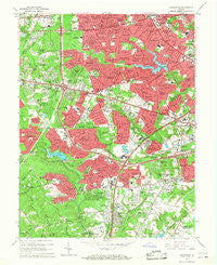
~ Annandale VA topo map, 1:24000 scale, 7.5 X 7.5 Minute, Historical, 1965, updated 1968
Annandale, Virginia, USGS topographic map dated 1965.
Includes geographic coordinates (latitude and longitude). This topographic map is suitable for hiking, camping, and exploring, or framing it as a wall map.
Printed on-demand using high resolution imagery, on heavy weight and acid free paper, or alternatively on a variety of synthetic materials.
Topos available on paper, Waterproof, Poly, or Tyvek. Usually shipping rolled, unless combined with other folded maps in one order.
- Product Number: USGS-5296235
- Free digital map download (high-resolution, GeoPDF): Annandale, Virginia (file size: 13 MB)
- Map Size: please refer to the dimensions of the GeoPDF map above
- Weight (paper map): ca. 55 grams
- Map Type: POD USGS Topographic Map
- Map Series: HTMC
- Map Verison: Historical
- Cell ID: 1073
- Scan ID: 183925
- Imprint Year: 1968
- Woodland Tint: Yes
- Aerial Photo Year: 1955
- Edit Year: 1965
- Field Check Year: 1956
- Datum: NAD27
- Map Projection: Polyconic
- Map published by United States Geological Survey
- Map Language: English
- Scanner Resolution: 600 dpi
- Map Cell Name: Annandale
- Grid size: 7.5 X 7.5 Minute
- Date on map: 1965
- Map Scale: 1:24000
- Geographical region: Virginia, United States
Neighboring Maps:
All neighboring USGS topo maps are available for sale online at a variety of scales.
Spatial coverage:
Topo map Annandale, Virginia, covers the geographical area associated the following places:
- Lincolnia - Sleepy Hollow Woods - Maple Grove Estates - Guilford - Hillbrook - Wakefield Forest - Springfield Station - Pine Ridge - Jefferson Village - Malbrook - Camelot - Fair Vernon - Pohick Hills - Tyler Park - Homewood - Sleepy Hollow Estates - Ravenwood - Lynbrook - Lee Boulevard Heights - Monticello Woods - Mill Creek Park - Pinecrest - Broyhill Park - Cameron Villa Farms - Alpine - Cedar Crest - Lunt - Devonshire Gardens - Walhaven - Westview Hills - Tremont Gardens - Hayfield - Holmes Run Park - Bristow - Kings Park - Franconia - Springvale - Barkers Crossroads - Masonville - Bon Air - Broyhill Crest - Cardinal Forest - Glencarlyn - Keene Mill Manor - Monticello Forest - Springfield Square - Columbia Pines - Holmes Run Heights - Belvedere - Woodley - Mount Pleasant - Beverly Forest - Springfield Estates - Ravensworth - Fairfax Hills - Brookland Estates - Annalee Heights - Bel Air - Kenwood - Dowden Terrace - Weyanoke - Culmore - Holmes Run Acres - Sleepy Hollow Manor - Sleepy Hollow - New Hope - Walters Woods - Loisdale Estates - Fair Vernon - Seven Corners - Woodburn - Windsor Estates - Fairland - Jefferson - Annandale - Ravensworth Grove - Sunset Manor - Wilburdale - Silver Springs - Pine Spring - Leewood - Ravensworth Park - Cameron - Springfield - Edsall Park - North Springfield - Strathmeade Springs - Kathmoor - Pleasant Ridge - Yates Village - West Springfield - Baileys Crossroads - Crestwood Manor - Courtland Park - Canterbury Woods - Villa Del-Ray - Mount Hebron Park - Bren Mar Park - Fairfax Park - Accotink Heights
- Map Area ID: AREA38.87538.75-77.25-77.125
- Northwest corner Lat/Long code: USGSNW38.875-77.25
- Northeast corner Lat/Long code: USGSNE38.875-77.125
- Southwest corner Lat/Long code: USGSSW38.75-77.25
- Southeast corner Lat/Long code: USGSSE38.75-77.125
- Northern map edge Latitude: 38.875
- Southern map edge Latitude: 38.75
- Western map edge Longitude: -77.25
- Eastern map edge Longitude: -77.125


