
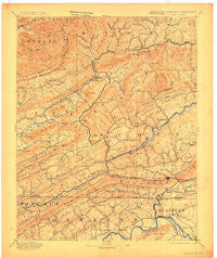
~ Estillville VA topo map, 1:125000 scale, 30 X 30 Minute, Historical, 1894, updated 1909
Estillville, Virginia, USGS topographic map dated 1894.
Includes geographic coordinates (latitude and longitude). This topographic map is suitable for hiking, camping, and exploring, or framing it as a wall map.
Printed on-demand using high resolution imagery, on heavy weight and acid free paper, or alternatively on a variety of synthetic materials.
Topos available on paper, Waterproof, Poly, or Tyvek. Usually shipping rolled, unless combined with other folded maps in one order.
- Product Number: USGS-5294894
- Free digital map download (high-resolution, GeoPDF): Estillville, Virginia (file size: 7 MB)
- Map Size: please refer to the dimensions of the GeoPDF map above
- Weight (paper map): ca. 55 grams
- Map Type: POD USGS Topographic Map
- Map Series: HTMC
- Map Verison: Historical
- Cell ID: 65454
- Scan ID: 708606
- Imprint Year: 1909
- Survey Year: 1891
- Datum: Unstated
- Map Projection: Unstated
- Map published by United States Geological Survey
- Map Language: English
- Scanner Resolution: 508 dpi
- Map Cell Name: Estillville
- Grid size: 30 X 30 Minute
- Date on map: 1894
- Map Scale: 1:125000
- Geographical region: Virginia, United States
Neighboring Maps:
All neighboring USGS topo maps are available for sale online at a variety of scales.
Spatial coverage:
Topo map Estillville, Virginia, covers the geographical area associated the following places:
- Fair Acres - Rotherwood - Weber City - Gate City - Josephine - Glenita - Jayne Mill - Sloantown - East Stone Gap - Spivey Mill - Doran Addition - Mohawk (historical) - Clinchport - Bloomington Heights - Deep Springs - Harvey - East Kingsport - Irondale - Seminary - Nottingham - Graden - Clark (historical) - Skyview Estates - Blair - Hemlock Park - Olinger - Spivey Store - Sigma - Addington - Sunbright - Howard Hill - Wise - Cox Place - Northcott - Cedar Grove - Bays Cove - Mountain Springs - Lynn Garden - Grays - West View Park - Marcem - Greenfields - Springdale - Stephens - Cherokee Village - Flat Rock - Ramsey - Jasper - Cumberland - Delvale - Rye Cove - Pattonsville - Cliffside - Greenvale - Thomas Addition - Newtown - Lewis Lane - Midway - Beamantown - Sunset Hills - Needmore - Midfields - Linden - Laurel Grove - Arno - Rawhide - Dona - Green Village - Horace (historical) - Craft Mill - Beechwood Village - Fairview - Rotherwood Hills - Fisher Creek - Big Springs - Winegar Mill - Boulder - Rotherwood Heights - Yuma - Kingsport - Holston Heights - Duncan Mill - Tito - Shepherd Hill - Buckles (historical) - Wood - Allandale - Mintons Store - Aunt (historical) - Hawthorne - Dorter Mill - Ridgefields - Bellamy - Derby - Stanleytown - Roda - Amersham - Ponderosa Estates - Borden Village - Greenland
- Map Area ID: AREA3736.5-83-82.5
- Northwest corner Lat/Long code: USGSNW37-83
- Northeast corner Lat/Long code: USGSNE37-82.5
- Southwest corner Lat/Long code: USGSSW36.5-83
- Southeast corner Lat/Long code: USGSSE36.5-82.5
- Northern map edge Latitude: 37
- Southern map edge Latitude: 36.5
- Western map edge Longitude: -83
- Eastern map edge Longitude: -82.5


