
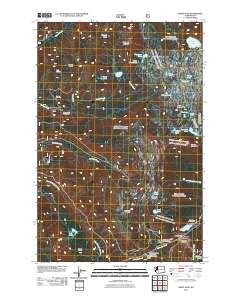
~ White Pass WA topo map, 1:24000 scale, 7.5 X 7.5 Minute, Historical, 2011
White Pass, Washington, USGS topographic map dated 2011.
Includes geographic coordinates (latitude and longitude). This topographic map is suitable for hiking, camping, and exploring, or framing it as a wall map.
Printed on-demand using high resolution imagery, on heavy weight and acid free paper, or alternatively on a variety of synthetic materials.
Topos available on paper, Waterproof, Poly, or Tyvek. Usually shipping rolled, unless combined with other folded maps in one order.
- Product Number: USGS-5265999
- Free digital map download (high-resolution, GeoPDF): White Pass, Washington (file size: 20 MB)
- Map Size: please refer to the dimensions of the GeoPDF map above
- Weight (paper map): ca. 55 grams
- Map Type: POD USGS Topographic Map
- Map Series: US Topo
- Map Verison: Historical
- Cell ID: 72049
- Datum: North American Datum of 1983
- Map Projection: Transverse Mercator
- Map Cell Name: White Pass
- Grid size: 7.5 X 7.5 Minute
- Date on map: 2011
- Map Scale: 1:24000
- Geographical region: Washington, United States
Neighboring Maps:
All neighboring USGS topo maps are available for sale online at a variety of scales.
Spatial coverage:
Topo map White Pass, Washington, covers the geographical area associated the following places:
- Allred Creek - Skeelter Shelter - Jug Lake - Deer Lake - Penoyer Lake - Snow Lake - Benchmark Lake - Cortright Point - Log Spring - Little Snow Lake - Jess Lake - Lily Lake - Cramer Mountain - White Pass X Country Ski Area - Twin Sisters Lakes - Beusch Lake - Millridge Creek - Knuppenburg Lake - Kincaid Lake - Dark Meadows Trail - Sand Lake Trail - Cortright Creek Trail - Dumbbell Lake - Cowlitz Trailhead - Fryingpan Mountain - Skeeter Shelter - Carlton Ridge - Soda Springs Campground - Clear Fork Trail - Cowlitz Pass - Cowlitz Trail - Knuppenburg Lake Campground - Pipe Lake - Henry Lake - Leech Lake - Kincaid Trail - Lake Trail - Jug Lake Trail - Fryingpan Lake - Pony Creek - White Pass - Sand Lake Shelter - Chain Lakes - Deerhead Lake - Bill Lake - White Pass Ski Area - Sand Lake - Ginnette Lake - White Pass Campground
- Map Area ID: AREA46.7546.625-121.5-121.375
- Northwest corner Lat/Long code: USGSNW46.75-121.5
- Northeast corner Lat/Long code: USGSNE46.75-121.375
- Southwest corner Lat/Long code: USGSSW46.625-121.5
- Southeast corner Lat/Long code: USGSSE46.625-121.375
- Northern map edge Latitude: 46.75
- Southern map edge Latitude: 46.625
- Western map edge Longitude: -121.5
- Eastern map edge Longitude: -121.375


