
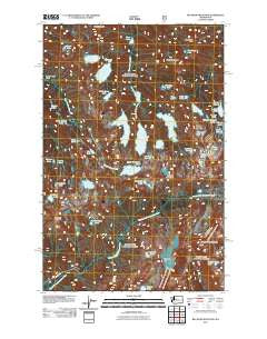
~ Big Snow Mountain WA topo map, 1:24000 scale, 7.5 X 7.5 Minute, Historical, 2011
Big Snow Mountain, Washington, USGS topographic map dated 2011.
Includes geographic coordinates (latitude and longitude). This topographic map is suitable for hiking, camping, and exploring, or framing it as a wall map.
Printed on-demand using high resolution imagery, on heavy weight and acid free paper, or alternatively on a variety of synthetic materials.
Topos available on paper, Waterproof, Poly, or Tyvek. Usually shipping rolled, unless combined with other folded maps in one order.
- Product Number: USGS-5257502
- Free digital map download (high-resolution, GeoPDF): Big Snow Mountain, Washington (file size: 21 MB)
- Map Size: please refer to the dimensions of the GeoPDF map above
- Weight (paper map): ca. 55 grams
- Map Type: POD USGS Topographic Map
- Map Series: US Topo
- Map Verison: Historical
- Cell ID: 3835
- Datum: North American Datum of 1983
- Map Projection: Transverse Mercator
- Map Cell Name: Big Snow Mountain
- Grid size: 7.5 X 7.5 Minute
- Date on map: 2011
- Map Scale: 1:24000
- Geographical region: Washington, United States
Neighboring Maps:
All neighboring USGS topo maps are available for sale online at a variety of scales.
Spatial coverage:
Topo map Big Snow Mountain, Washington, covers the geographical area associated the following places:
- Silver Eagle Peak - Hardscrabble Creek - Fools Gold Lake - Gold Lake - Crawford Creek - Tahl Lake - Summit Chief Mountain - Malachite Falls - Chetwoot Lake - Big Snow Mountain - Moira Lake - Summit Chief Lake - Tank Lakes - Lake Ilswoot - Little Heart Lake - Emerald Lake - Malachite Peak - Gus Lake - Necklace Valley - Snowflake Lake - Charlie Lakes - Big Snow Lake - Bald Eagle Peak - Jewel Lake - Overcoat Peak - Hinter Lake - Azurite Lake - Angeline Lake - Big Heart Lake - Iceberg Lake - Hardscrabble Lakes - Opal Lake - Lake Malachite - Locket Lake - Overcoat Lake - Iron Cap Mountain - Necklace Valley Lakes - Crawford Lake - Trout Lake - View Lake - Azure Lake - Foehn Lake - Cecils Lake - Delta Lake - Little Chetwoot Lake - Otter Lake - Bald Eagle Lake - Bonnie Lake - Chimney Rock - Camp Robber Lake - Jade Lake - Cloudy Lake - Nazanne Lake - Marlene Lake - Copper Lake
- Map Area ID: AREA47.62547.5-121.375-121.25
- Northwest corner Lat/Long code: USGSNW47.625-121.375
- Northeast corner Lat/Long code: USGSNE47.625-121.25
- Southwest corner Lat/Long code: USGSSW47.5-121.375
- Southeast corner Lat/Long code: USGSSE47.5-121.25
- Northern map edge Latitude: 47.625
- Southern map edge Latitude: 47.5
- Western map edge Longitude: -121.375
- Eastern map edge Longitude: -121.25


