
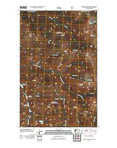
~ Ashnola Mountain WA topo map, 1:24000 scale, 7.5 X 7.5 Minute, Historical, 2011
Ashnola Mountain, Washington, USGS topographic map dated 2011.
Includes geographic coordinates (latitude and longitude). This topographic map is suitable for hiking, camping, and exploring, or framing it as a wall map.
Printed on-demand using high resolution imagery, on heavy weight and acid free paper, or alternatively on a variety of synthetic materials.
Topos available on paper, Waterproof, Poly, or Tyvek. Usually shipping rolled, unless combined with other folded maps in one order.
- Product Number: USGS-5257007
- Free digital map download (high-resolution, GeoPDF): Ashnola Mountain, Washington (file size: 18 MB)
- Map Size: please refer to the dimensions of the GeoPDF map above
- Weight (paper map): ca. 55 grams
- Map Type: POD USGS Topographic Map
- Map Series: US Topo
- Map Verison: Historical
- Cell ID: 1684
- Datum: North American Datum of 1983
- Map Projection: Transverse Mercator
- Map Cell Name: Ashnola Mountain
- Grid size: 7.5 X 7.5 Minute
- Date on map: 2011
- Map Scale: 1:24000
- Geographical region: Washington, United States
Neighboring Maps:
All neighboring USGS topo maps are available for sale online at a variety of scales.
Spatial coverage:
Topo map Ashnola Mountain, Washington, covers the geographical area associated the following places:
- West Fork Ptarmigan Creek - Dean Creek - Stub Creek - Whistler Pass - Whistler Basin - Dollar Watch Pass - Snowslide Creek - Murphy Creek - Hidden Lakes - Sand Ridge - Gray Mountain - Quartz Lake - Bunker Hill - Dollar Watch Mountain - Cougar Lake - First Hidden Lake - Middle Hidden Lake - Island Mountain - Sheep Lake - Two Point Mountain - Ramon Lakes - Peeve Pass - Island Lake - Mayo Creek - Whistler Creek - Deception Pass - Ashnola Mountain - Quartz Creek - Middle Mountain - Ptarmigan Creek - Little Willy Creek - Park Pass - McCall Gulch - Boundary Trail - Gunbarrel Creek - Sheep Mountain - Quartz Mountain
- Map Area ID: AREA4948.875-120.5-120.375
- Northwest corner Lat/Long code: USGSNW49-120.5
- Northeast corner Lat/Long code: USGSNE49-120.375
- Southwest corner Lat/Long code: USGSSW48.875-120.5
- Southeast corner Lat/Long code: USGSSE48.875-120.375
- Northern map edge Latitude: 49
- Southern map edge Latitude: 48.875
- Western map edge Longitude: -120.5
- Eastern map edge Longitude: -120.375


