
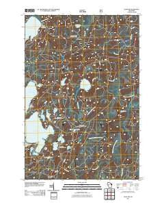
~ Alvin NW WI topo map, 1:24000 scale, 7.5 X 7.5 Minute, Historical, 2011
Alvin NW, Wisconsin, USGS topographic map dated 2011.
Includes geographic coordinates (latitude and longitude). This topographic map is suitable for hiking, camping, and exploring, or framing it as a wall map.
Printed on-demand using high resolution imagery, on heavy weight and acid free paper, or alternatively on a variety of synthetic materials.
Topos available on paper, Waterproof, Poly, or Tyvek. Usually shipping rolled, unless combined with other folded maps in one order.
- Product Number: USGS-5255564
- Free digital map download (high-resolution, GeoPDF): Alvin NW, Wisconsin (file size: 21 MB)
- Map Size: please refer to the dimensions of the GeoPDF map above
- Weight (paper map): ca. 55 grams
- Map Type: POD USGS Topographic Map
- Map Series: US Topo
- Map Verison: Historical
- Cell ID: 800
- Datum: North American Datum of 1983
- Map Projection: Transverse Mercator
- Map Cell Name: Alvin NW
- Grid size: 7.5 X 7.5 Minute
- Date on map: 2011
- Map Scale: 1:24000
- Geographical region: Wisconsin, United States
Neighboring Maps:
All neighboring USGS topo maps are available for sale online at a variety of scales.
Spatial coverage:
Topo map Alvin NW, Wisconsin, covers the geographical area associated the following places:
- Perry Spring - Briss Lake - Bose Lake Hemlock-Hardwoods State Natural Area - Indian Camp Lake - Butternut Lake - Quartz Lake - White Deer Lake - Griswolds Camp - Four Ducks Lake - Lone Wolf Lake - Kentuck Lake Campground - Kentuck Creek - Harriet Lake - Franklin Lake Campground - Sunfish Lake - Harmony Lake - Forks Dam - Kentuck Lake - Reservoir Lake - Camp White Deer - Bose Lake - Three Johns Lake - Howell Creek - Brule Springs - Mayflower Lake - Luna Lake - Camp 14 (historical) - Rosen Dam - Luna-White Deer Campground - Two Sisters Lakes - Howell Lake - McKinley Lake - North Branch McDonald Creek
- Map Area ID: AREA4645.875-89-88.875
- Northwest corner Lat/Long code: USGSNW46-89
- Northeast corner Lat/Long code: USGSNE46-88.875
- Southwest corner Lat/Long code: USGSSW45.875-89
- Southeast corner Lat/Long code: USGSSE45.875-88.875
- Northern map edge Latitude: 46
- Southern map edge Latitude: 45.875
- Western map edge Longitude: -89
- Eastern map edge Longitude: -88.875


