
~ Ogden UT topo map, 1:24000 scale, 7.5 X 7.5 Minute, Historical, 2011
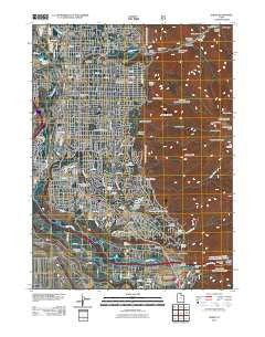
Ogden, Utah, USGS topographic map dated 2011.
Includes geographic coordinates (latitude and longitude). This topographic map is suitable for hiking, camping, and exploring, or framing it as a wall map.
Printed on-demand using high resolution imagery, on heavy weight and acid free paper, or alternatively on a variety of synthetic materials.
Topos available on paper, Waterproof, Poly, or Tyvek. Usually shipping rolled, unless combined with other folded maps in one order.
- Product Number: USGS-5255314
- Free digital map download (high-resolution, GeoPDF): Ogden, Utah (file size: 23 MB)
- Map Size: please refer to the dimensions of the GeoPDF map above
- Weight (paper map): ca. 55 grams
- Map Type: POD USGS Topographic Map
- Map Series: US Topo
- Map Verison: Historical
- Cell ID: 32952
- Datum: North American Datum of 1983
- Map Projection: Transverse Mercator
- Map Cell Name: Ogden
- Grid size: 7.5 X 7.5 Minute
- Date on map: 2011
- Map Scale: 1:24000
- Geographical region: Utah, United States
Neighboring Maps:
All neighboring USGS topo maps are available for sale online at a variety of scales.
Spatial coverage:
Topo map Ogden, Utah, covers the geographical area associated the following places:
- C and G Estates - Cherrywood Condominium - Bel-Mar Acres - Stones Orchard Addition - R C Hunter - Southridge Nine - Canyon Park - Brummitts Addition - Southridge Subdivision 5 - Wallace - Pearwood Park - University Place - Olympus Heights - Childs Addition - The Meadows PRUD - Woodland Estates - Hale Addition - Rolling Hills Additions 2-7 - Main Point Condominium - River View Addition - Rushton Addition - West Ogden Addition - Lark Circle - East Park Addition - University Place Addition - Hassell Heights - El-May - Moffitts - Eastwood Subdivision Number 6 - Ridgeline - Manhattan - The Meadows East PRUD - River Valley Estates - Avondet - Canyon Terrace Condominium - Washington Terrace - Corcys - River Valley - Ben Lomond Heights - Lovelock - Forestdale Addition - Grandview Acres - Mount Ogden Terrace Condominium Project - Stephens - Knollwood Estates Plat One - Oak Wood Heights - Bichsels East - Hunter Hill Addition - Forest Green Estates - Bowers Addition - Orchard Park Subdivision Number 3-7 - Burnett - Mountain View Addition - Ridgepoint - Hunters - Weese Addition - Greenwood Village - Nob Hill Annex - Country Club Heights Addition - Valle Grande Condominium - Mountain Oaks Estates Number 1 - High View - Langford - Stallard - Dankowske Central - South Weber - East Bench at 29th - Pepperwood Condominium - Monte Vista - Hillcrest Addition - Washington Terrace Parcel H - Eastwood Subdivision Number 5 - Riverside Addition - Tibbitts - Yorkshire Meadows Condominium - Central Park Annex - The Capitol Building Condominium - Franklin Place Addition - Old Mill Subdivision Phase 1-3 - Cross - Oak Ridge Acres - Wasatch Hills Addition - Sherwood Park - El Monte Vista - Eastwood Subdivision Number 2 - Solitude Condominium - Oak View Estates - Country Hills Addition - Olsen - Dundee Place - F T Sanfords - Century Village - University Heights - White Addition - Fister-Martin - Bichsels West - Nelson Park Addition - The Meadows Condominium - Duffin Heights - Sherwood Meadows
- Map Area ID: AREA41.2541.125-112-111.875
- Northwest corner Lat/Long code: USGSNW41.25-112
- Northeast corner Lat/Long code: USGSNE41.25-111.875
- Southwest corner Lat/Long code: USGSSW41.125-112
- Southeast corner Lat/Long code: USGSSE41.125-111.875
- Northern map edge Latitude: 41.25
- Southern map edge Latitude: 41.125
- Western map edge Longitude: -112
- Eastern map edge Longitude: -111.875


