
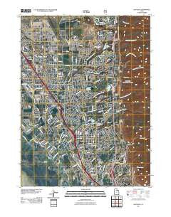
~ Kaysville UT topo map, 1:24000 scale, 7.5 X 7.5 Minute, Historical, 2011
Kaysville, Utah, USGS topographic map dated 2011.
Includes geographic coordinates (latitude and longitude). This topographic map is suitable for hiking, camping, and exploring, or framing it as a wall map.
Printed on-demand using high resolution imagery, on heavy weight and acid free paper, or alternatively on a variety of synthetic materials.
Topos available on paper, Waterproof, Poly, or Tyvek. Usually shipping rolled, unless combined with other folded maps in one order.
- Product Number: USGS-5255290
- Free digital map download (high-resolution, GeoPDF): Kaysville, Utah (file size: 21 MB)
- Map Size: please refer to the dimensions of the GeoPDF map above
- Weight (paper map): ca. 55 grams
- Map Type: POD USGS Topographic Map
- Map Series: US Topo
- Map Verison: Historical
- Cell ID: 23103
- Datum: North American Datum of 1983
- Map Projection: Transverse Mercator
- Map Cell Name: Kaysville
- Grid size: 7.5 X 7.5 Minute
- Date on map: 2011
- Map Scale: 1:24000
- Geographical region: Utah, United States
Neighboring Maps:
All neighboring USGS topo maps are available for sale online at a variety of scales.
Spatial coverage:
Topo map Kaysville, Utah, covers the geographical area associated the following places:
- Rolling Greens - Farmington Orchards - Hodson Estates - Cherry Farm Estates - Robins Park - The Oaks at Mutton Hollow - Green Mountain Estates - King Farm Estates - Diamond Hills - Dawn Development - Indian Oaks - Fairway Fields - Pilly Green - Sundowner Condominium - Country Oaks - Jones - East Layton - Dimond Oaks - Snow Creek - Oak Lane Heights - Country Meadows - Riley - Park View Estates - Oak Forest Two - Hen Farm Estates - Happy Home Five - Kaysville Heights - Woodridge Estates - Snow Canyon - Koziar Hills - Oakridge Terrace - Village Green - Park Heights - Barton Manor Three - Glendale Gardens - Grand Oaks - Brook Haven - Shepherd Creek County Estates - Upland - Eastridge Estates - Twin Creek Estates - Moon Park - Fort Lane Plaza Condominium - Dreams End - Layton - Oakridge Village Condominium - Cherry View - Eastview - Avion Vista - Heath - Marshall Heights - Country Estates - Country Oaks Condominium - Oakridge Farms - Rachels Place - Summer Wood - Fort Lane - Four Corners - Rolling Oaks - Victorian Oaks - Clover Estates - Somerset Farm - Lakewood - Oakmont Acres - North Hills Estates - Nayon Heights Condominium - Heatherglen - Haven Park - Farifield Park - Laytona - Kimberly Meadows - Clair Black - Simmons - Wooded Hills - Cameron Estates - Oak Hill - Country Creek Estates - Townhouse Condominium - Green Oaks Estates - Summer Haze - Mount Air Estates - Barton Manor Two - Fairfield Condominium - Aspen East - East Crest Estates - Summerfield - Vera Lee - Woodridge Twin Homes - Skyline Addition - Whitesides Estates - Kent Estates - Oak Hollow - Gill - Barnes Estates - Natural Estates - Oak Forest One - Meadowbrook Hollow - Robinwood - The Orchard - Eastwood Estates
- Map Area ID: AREA41.12541-112-111.875
- Northwest corner Lat/Long code: USGSNW41.125-112
- Northeast corner Lat/Long code: USGSNE41.125-111.875
- Southwest corner Lat/Long code: USGSSW41-112
- Southeast corner Lat/Long code: USGSSE41-111.875
- Northern map edge Latitude: 41.125
- Southern map edge Latitude: 41
- Western map edge Longitude: -112
- Eastern map edge Longitude: -111.875


