
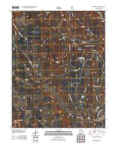
~ Webster Flat UT topo map, 1:24000 scale, 7.5 X 7.5 Minute, Historical, 2011
Webster Flat, Utah, USGS topographic map dated 2011.
Includes geographic coordinates (latitude and longitude). This topographic map is suitable for hiking, camping, and exploring, or framing it as a wall map.
Printed on-demand using high resolution imagery, on heavy weight and acid free paper, or alternatively on a variety of synthetic materials.
Topos available on paper, Waterproof, Poly, or Tyvek. Usually shipping rolled, unless combined with other folded maps in one order.
- Product Number: USGS-5251118
- Free digital map download (high-resolution, GeoPDF): Webster Flat, Utah (file size: 22 MB)
- Map Size: please refer to the dimensions of the GeoPDF map above
- Weight (paper map): ca. 55 grams
- Map Type: POD USGS Topographic Map
- Map Series: US Topo
- Map Verison: Historical
- Cell ID: 47920
- Datum: North American Datum of 1983
- Map Projection: Transverse Mercator
- Map Cell Name: Webster Flat
- Grid size: 7.5 X 7.5 Minute
- Date on map: 2011
- Map Scale: 1:24000
- Geographical region: Utah, United States
Neighboring Maps:
All neighboring USGS topo maps are available for sale online at a variety of scales.
Spatial coverage:
Topo map Webster Flat, Utah, covers the geographical area associated the following places:
- Spanish Hollow - Cedar Canyon Ski Area - Cedar Canyon Campground - Webster Flat - O'Neil Point - Steamboat - China Point - Wood Ranch - Three Creeks Flat - Kolob Terrace - Schoppmann Hollow - Everstein Ridge - Bauer Point - Sherratt Point - Moots Hollow - Black Mountain - East Fork Deep Creek - Big Spring - Wood Knoll - Crystal Creek - Corry Point - Deer Haven Campground - Urie Creek - Blowhard Hollow - Zion Overlook - Adams Hollow - Aspen Lake - Lundell Spring - Houchen Hollow - Slide Hollow - Dan Leigh Hollow - Crystal Spring - Jackson Point - Miners Peak - Everstein Hollow - Walts Flat
- Map Area ID: AREA37.62537.5-113-112.875
- Northwest corner Lat/Long code: USGSNW37.625-113
- Northeast corner Lat/Long code: USGSNE37.625-112.875
- Southwest corner Lat/Long code: USGSSW37.5-113
- Southeast corner Lat/Long code: USGSSE37.5-112.875
- Northern map edge Latitude: 37.625
- Southern map edge Latitude: 37.5
- Western map edge Longitude: -113
- Eastern map edge Longitude: -112.875


