
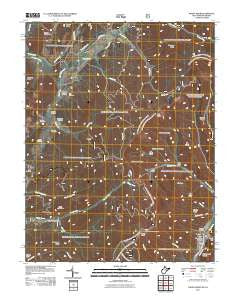
~ Paddy Knob WV topo map, 1:24000 scale, 7.5 X 7.5 Minute, Historical, 2011
Paddy Knob, West Virginia, USGS topographic map dated 2011.
Includes geographic coordinates (latitude and longitude). This topographic map is suitable for hiking, camping, and exploring, or framing it as a wall map.
Printed on-demand using high resolution imagery, on heavy weight and acid free paper, or alternatively on a variety of synthetic materials.
Topos available on paper, Waterproof, Poly, or Tyvek. Usually shipping rolled, unless combined with other folded maps in one order.
- Product Number: USGS-5245144
- Free digital map download (high-resolution, GeoPDF): Paddy Knob, West Virginia (file size: 28 MB)
- Map Size: please refer to the dimensions of the GeoPDF map above
- Weight (paper map): ca. 55 grams
- Map Type: POD USGS Topographic Map
- Map Series: US Topo
- Map Verison: Historical
- Cell ID: 33866
- Datum: North American Datum of 1983
- Map Projection: Transverse Mercator
- Map Cell Name: Paddy Knob
- Grid size: 7.5 X 7.5 Minute
- Date on map: 2011
- Map Scale: 1:24000
- Geographical region: West Virginia, United States
Neighboring Maps:
All neighboring USGS topo maps are available for sale online at a variety of scales.
Spatial coverage:
Topo map Paddy Knob, West Virginia, covers the geographical area associated the following places:
- Shock Run - Wesley Chapel School (historical) - Bridge Hollow - Gum Branch - Paddy Knob Trail - Thorny Branch - Dilly Cemetery - Paddy Knob Lookout Tower - Bird Run - Buzzard Cemetery - Camp Copperhead (historical) - Lick Draft - Chocklett Spring - Big Ridge - Pine Ridge - Moore Cemetery - Lindsay Cemetery - Chestnut Ridge - Charley Ridge - Big End - Gum Spring School (historical) - Lower Gap - Bear Hollow - Gragg Cemetery - Lick Points - Gregory Ridge - Buzzard Cemetery - Dunmore Spring - Meadow Spring - Kent Simmons Hollow - New Hope Church - Mount Pleasant School (historical) - Brushy Ridge - Hillside School (historical) - Stony Run - Chestnut Ridge - Campground Hollow - Steep Pinch Ridge - Left Prong Galford Run - Sorrel Point Ridge - Mad Sheep Ridge - Shinaberry Cemetery - Lower Mountain - Galford Run - Little Ridge - Bussard Cemetery - Garfield Grimes Spring - Wesley Chapel - Bird Run Campground - Slate Lick Knob - Paddy Knob - Big Crooked Ridge - Jakes Run
- Map Area ID: AREA38.37538.25-79.875-79.75
- Northwest corner Lat/Long code: USGSNW38.375-79.875
- Northeast corner Lat/Long code: USGSNE38.375-79.75
- Southwest corner Lat/Long code: USGSSW38.25-79.875
- Southeast corner Lat/Long code: USGSSE38.25-79.75
- Northern map edge Latitude: 38.375
- Southern map edge Latitude: 38.25
- Western map edge Longitude: -79.875
- Eastern map edge Longitude: -79.75


