
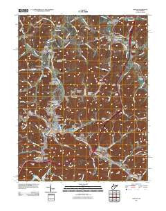
~ Weston WV topo map, 1:24000 scale, 7.5 X 7.5 Minute, Historical, 2011
Weston, West Virginia, USGS topographic map dated 2011.
Includes geographic coordinates (latitude and longitude). This topographic map is suitable for hiking, camping, and exploring, or framing it as a wall map.
Printed on-demand using high resolution imagery, on heavy weight and acid free paper, or alternatively on a variety of synthetic materials.
Topos available on paper, Waterproof, Poly, or Tyvek. Usually shipping rolled, unless combined with other folded maps in one order.
- Product Number: USGS-5244515
- Free digital map download (high-resolution, GeoPDF): Weston, West Virginia (file size: 23 MB)
- Map Size: please refer to the dimensions of the GeoPDF map above
- Weight (paper map): ca. 55 grams
- Map Type: POD USGS Topographic Map
- Map Series: US Topo
- Map Verison: Historical
- Cell ID: 48440
- Datum: North American Datum of 1983
- Map Projection: Transverse Mercator
- Map Cell Name: Weston
- Grid size: 7.5 X 7.5 Minute
- Date on map: 2011
- Map Scale: 1:24000
- Geographical region: West Virginia, United States
Neighboring Maps:
All neighboring USGS topo maps are available for sale online at a variety of scales.
Spatial coverage:
Topo map Weston, West Virginia, covers the geographical area associated the following places:
- Donlan Heights - Edgewood - Weston Arbors - Smith Village - Weston - Westfield - Fisher Hill - Riverview Heights - Mace Addition - McGary - Straley Addition - South Park - Horner - Gaston Manor - Ben Dale - Dolan Trailer Park - Butchersville - Haleville - Brownsville - McGuire Park - Buck Hill - Kitsonville - Homeland - Shady Brook - Pinecrest Addition - Hall Trailer Park - Deanville - Homewood - Los Anglin - Valley Chapel - Jackson Heights - Garton Village - Jackson Acres - Hickory Hills - Weston Manor - Gaston - Woodland Addition - Turnertown - Jackson Mill - South Park Trailer Park - Lightburn Acres - Circle Heights - Hall Addition - Cox Town - Sunset Acres - Quiet Dale - Jane Lew
- Map Area ID: AREA39.12539-80.5-80.375
- Northwest corner Lat/Long code: USGSNW39.125-80.5
- Northeast corner Lat/Long code: USGSNE39.125-80.375
- Southwest corner Lat/Long code: USGSSW39-80.5
- Southeast corner Lat/Long code: USGSSE39-80.375
- Northern map edge Latitude: 39.125
- Southern map edge Latitude: 39
- Western map edge Longitude: -80.5
- Eastern map edge Longitude: -80.375


