
~ Spanish Bottom UT topo map, 1:24000 scale, 7.5 X 7.5 Minute, Historical, 2010
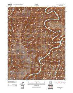
Spanish Bottom, Utah, USGS topographic map dated 2010.
Includes geographic coordinates (latitude and longitude). This topographic map is suitable for hiking, camping, and exploring, or framing it as a wall map.
Printed on-demand using high resolution imagery, on heavy weight and acid free paper, or alternatively on a variety of synthetic materials.
Topos available on paper, Waterproof, Poly, or Tyvek. Usually shipping rolled, unless combined with other folded maps in one order.
- Product Number: USGS-5239202
- Free digital map download (high-resolution, GeoPDF): Spanish Bottom, Utah (file size: 25 MB)
- Map Size: please refer to the dimensions of the GeoPDF map above
- Weight (paper map): ca. 55 grams
- Map Type: POD USGS Topographic Map
- Map Series: US Topo
- Map Verison: Historical
- Cell ID: 42388
- Datum: North American Datum of 1983
- Map Projection: Transverse Mercator
- Map Cell Name: Spanish Bottom
- Grid size: 7.5 X 7.5 Minute
- Date on map: 2010
- Map Scale: 1:24000
- Geographical region: Utah, United States
Neighboring Maps:
All neighboring USGS topo maps are available for sale online at a variety of scales.
Spatial coverage:
Topo map Spanish Bottom, Utah, covers the geographical area associated the following places:
- Land of Standing Rocks - West Fork Twin Canyon - Lower Red Lake Canyon - Shot Canyon - Red Lake Canyon - Jasper Canyon - Shot Canyon - Water Canyon - The Doll House - Thieves Cache Arch - North Flat - Suprise Valley - Canyonlands National Park - Jasper Canyon - Beehive Arch - Chimney Rock - Cave Cliff - Meander Canyon - The Plug - The Doll House - Sin-av-to-weap - Green River - The Confluence - Water Canyon - Land of Standing Rocks - Confluence Overlook - Lower Red Lake Canyon - Standing Rock - Aztec Canyon - Rim View - Land of Standing Rocks - Main Flat - Brown Betty Rapids - Twin Canyon - Chocolate Drops - Spanish Bottom - Muffin Arch - Lens Canyon - Stillwater Canyon - Butler Wash - Aztec Canyon - East Fork Twin Canyon - Petes Mesa
- Map Area ID: AREA38.2538.125-110-109.875
- Northwest corner Lat/Long code: USGSNW38.25-110
- Northeast corner Lat/Long code: USGSNE38.25-109.875
- Southwest corner Lat/Long code: USGSSW38.125-110
- Southeast corner Lat/Long code: USGSSE38.125-109.875
- Northern map edge Latitude: 38.25
- Southern map edge Latitude: 38.125
- Western map edge Longitude: -110
- Eastern map edge Longitude: -109.875


