
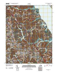
~ Williamsburg VA topo map, 1:24000 scale, 7.5 X 7.5 Minute, Historical, 2010
Williamsburg, Virginia, USGS topographic map dated 2010.
Includes geographic coordinates (latitude and longitude). This topographic map is suitable for hiking, camping, and exploring, or framing it as a wall map.
Printed on-demand using high resolution imagery, on heavy weight and acid free paper, or alternatively on a variety of synthetic materials.
Topos available on paper, Waterproof, Poly, or Tyvek. Usually shipping rolled, unless combined with other folded maps in one order.
- Product Number: USGS-5227064
- Free digital map download (high-resolution, GeoPDF): Williamsburg, Virginia (file size: 25 MB)
- Map Size: please refer to the dimensions of the GeoPDF map above
- Weight (paper map): ca. 55 grams
- Map Type: POD USGS Topographic Map
- Map Series: US Topo
- Map Verison: Historical
- Cell ID: 49173
- Datum: North American Datum of 1983
- Map Projection: Transverse Mercator
- Map Cell Name: Williamsburg
- Grid size: 7.5 X 7.5 Minute
- Date on map: 2010
- Map Scale: 1:24000
- Geographical region: Virginia, United States
Neighboring Maps:
All neighboring USGS topo maps are available for sale online at a variety of scales.
Spatial coverage:
Topo map Williamsburg, Virginia, covers the geographical area associated the following places:
- Old Quaker Estates - Barlows Corner - Forest Hill Park - Williamsburg - Banbury Cross - Springfield - Parkway Estates - Indigo Terrace - Skimino Farms - Queens Lake - Springfield Terrace - Middletowne Farms - Winston Terrace - York Terrace - Berkeley Hills - James Terrace - Skipwith Farms - Plantation Heights - Greensprings - Carriage Heights - Jamestown Farms - Walnut Hills - Schenck Estates - Canterbury Hills - Fort Magruder Heights - Porta Bello - Skimino Hills - The Hamlet - Old Stage Manor - Ewell - Burkes Corner - Williamsburg Terrace Mobile Home Park - Magruder - Druid Hills - James York Mobile Home Park - Charleston Heights - Oaktree - Skimino - Queenswood - Village of Williamsburg - Ewell Hall - The Mews - Rich Neck Heights - Chisel Run - Carver Gardens - Nelson Park - Colonial Park
- Map Area ID: AREA37.37537.25-76.75-76.625
- Northwest corner Lat/Long code: USGSNW37.375-76.75
- Northeast corner Lat/Long code: USGSNE37.375-76.625
- Southwest corner Lat/Long code: USGSSW37.25-76.75
- Southeast corner Lat/Long code: USGSSE37.25-76.625
- Northern map edge Latitude: 37.375
- Southern map edge Latitude: 37.25
- Western map edge Longitude: -76.75
- Eastern map edge Longitude: -76.625


