
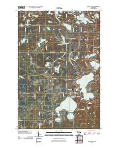
~ Ellison Lake WI topo map, 1:24000 scale, 7.5 X 7.5 Minute, Historical, 2010
Ellison Lake, Wisconsin, USGS topographic map dated 2010.
Includes geographic coordinates (latitude and longitude). This topographic map is suitable for hiking, camping, and exploring, or framing it as a wall map.
Printed on-demand using high resolution imagery, on heavy weight and acid free paper, or alternatively on a variety of synthetic materials.
Topos available on paper, Waterproof, Poly, or Tyvek. Usually shipping rolled, unless combined with other folded maps in one order.
- Product Number: USGS-5223570
- Free digital map download (high-resolution, GeoPDF): Ellison Lake, Wisconsin (file size: 22 MB)
- Map Size: please refer to the dimensions of the GeoPDF map above
- Weight (paper map): ca. 55 grams
- Map Type: POD USGS Topographic Map
- Map Series: US Topo
- Map Verison: Historical
- Cell ID: 14137
- Datum: North American Datum of 1983
- Map Projection: Transverse Mercator
- Map Cell Name: Ellison Lake
- Grid size: 7.5 X 7.5 Minute
- Date on map: 2010
- Map Scale: 1:24000
- Geographical region: Wisconsin, United States
Neighboring Maps:
All neighboring USGS topo maps are available for sale online at a variety of scales.
Spatial coverage:
Topo map Ellison Lake, Wisconsin, covers the geographical area associated the following places:
- Pickerel Lake - Ellison Lake - Little Island Lake - Black Fox Lake - Idlewild Lake - Highland Lookout Tower - Hopkins Lake - Middle Eau Claire Lake - Barnes Townhall - Tomahawk Lake - Mimi Lake - Lower Eau Claire Lake 55 - Murray Lake - Bony Lake - Middle Eau Claire Lake 57 - Rock Lake - Catherine Lake - Mooney Dam County Park - Mirror Lake - Mud Lake - Deer Print Lake - Barnes Volunteer Fire Department - Sand Bar Lake - Lower Eau Claire Lake Dam - Jack Pine Lake - Paradise Lake - Lund Lake - High Life Lake - Barnes Ambulance Service - Beauregard Lake - Cranberry Lake - Middle Eau Claire Lake 2WP366 Dam - Lower Eau Claire Lake
- Map Area ID: AREA46.37546.25-91.625-91.5
- Northwest corner Lat/Long code: USGSNW46.375-91.625
- Northeast corner Lat/Long code: USGSNE46.375-91.5
- Southwest corner Lat/Long code: USGSSW46.25-91.625
- Southeast corner Lat/Long code: USGSSE46.25-91.5
- Northern map edge Latitude: 46.375
- Southern map edge Latitude: 46.25
- Western map edge Longitude: -91.625
- Eastern map edge Longitude: -91.5


