
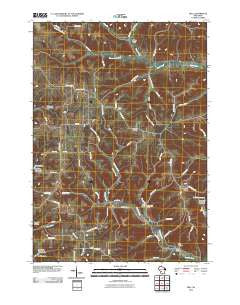
~ Dell WI topo map, 1:24000 scale, 7.5 X 7.5 Minute, Historical, 2010
Dell, Wisconsin, USGS topographic map dated 2010.
Includes geographic coordinates (latitude and longitude). This topographic map is suitable for hiking, camping, and exploring, or framing it as a wall map.
Printed on-demand using high resolution imagery, on heavy weight and acid free paper, or alternatively on a variety of synthetic materials.
Topos available on paper, Waterproof, Poly, or Tyvek. Usually shipping rolled, unless combined with other folded maps in one order.
- Product Number: USGS-5221628
- Free digital map download (high-resolution, GeoPDF): Dell, Wisconsin (file size: 19 MB)
- Map Size: please refer to the dimensions of the GeoPDF map above
- Weight (paper map): ca. 55 grams
- Map Type: POD USGS Topographic Map
- Map Series: US Topo
- Map Verison: Historical
- Cell ID: 11864
- Datum: North American Datum of 1983
- Map Projection: Transverse Mercator
- Map Cell Name: Dell
- Grid size: 7.5 X 7.5 Minute
- Date on map: 2010
- Map Scale: 1:24000
- Geographical region: Wisconsin, United States
Neighboring Maps:
All neighboring USGS topo maps are available for sale online at a variety of scales.
Spatial coverage:
Topo map Dell, Wisconsin, covers the geographical area associated the following places:
- Sugar Grove Church - Heiser Valley - Upper Brush Creek - Sunbeam Special School - Sandhill Ridge - Grove View School - Wolf Hollow - Clinton Center School (historical) - North Clinton School - South Clinton School - Sandhill School (historical) - Klinkner D 2592.2 Dam - Dell United Methodist Church - Fish Valley - Gallagher School (historical) - Bethany Church - Town of Clinton - Home Cemetery - Lower Brush Creek School (historical) - Brush Creek School - West Fork Kickapoo 12 D 2592.2 Dam - Irish Ridge - 2 Reservoir - Buckeye School (historical) - Twentyfour Valley - 2 Reservoir - Brush Creek - Charles Roberts G-4826 Dam - Upper Weister School (historical) - Woods Ridge School - O'Connell School (historical) - Dell - Potts Corners - 1 Reservoir - Sugar Grove School - 0.225 Reservoir - Oak Ridge Church - Lower Brush Creek - Bad Axe Cemetery
- Map Area ID: AREA43.7543.625-90.75-90.625
- Northwest corner Lat/Long code: USGSNW43.75-90.75
- Northeast corner Lat/Long code: USGSNE43.75-90.625
- Southwest corner Lat/Long code: USGSSW43.625-90.75
- Southeast corner Lat/Long code: USGSSE43.625-90.625
- Northern map edge Latitude: 43.75
- Southern map edge Latitude: 43.625
- Western map edge Longitude: -90.75
- Eastern map edge Longitude: -90.625


