
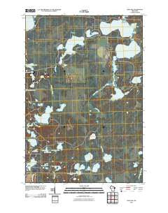
~ Dam Lake WI topo map, 1:24000 scale, 7.5 X 7.5 Minute, Historical, 2010
Dam Lake, Wisconsin, USGS topographic map dated 2010.
Includes geographic coordinates (latitude and longitude). This topographic map is suitable for hiking, camping, and exploring, or framing it as a wall map.
Printed on-demand using high resolution imagery, on heavy weight and acid free paper, or alternatively on a variety of synthetic materials.
Topos available on paper, Waterproof, Poly, or Tyvek. Usually shipping rolled, unless combined with other folded maps in one order.
- Product Number: USGS-5221484
- Free digital map download (high-resolution, GeoPDF): Dam Lake, Wisconsin (file size: 20 MB)
- Map Size: please refer to the dimensions of the GeoPDF map above
- Weight (paper map): ca. 55 grams
- Map Type: POD USGS Topographic Map
- Map Series: US Topo
- Map Verison: Historical
- Cell ID: 11263
- Datum: North American Datum of 1983
- Map Projection: Transverse Mercator
- Map Cell Name: Dam Lake
- Grid size: 7.5 X 7.5 Minute
- Date on map: 2010
- Map Scale: 1:24000
- Geographical region: Wisconsin, United States
Neighboring Maps:
All neighboring USGS topo maps are available for sale online at a variety of scales.
Spatial coverage:
Topo map Dam Lake, Wisconsin, covers the geographical area associated the following places:
- American Legion State Forest - Tim Lynn Lake - Little Spider Lake - Shallow Lake - Dam Lake - Spider Lake - Muskellunge Creek - Lynn Lake - Jenny Barnes Lake - Kate Pier Creek - Paradise Lake - Turtle Lake - Clear Lake - Indian Creek - Cranberry Lake - West Spider Lake - Muskellunge Lake - Pickerel Lake - Sand Lake - Echo Lake - Town of Newbold - Tom Doyle Lake - Lost Lake - Stone Lake - Dam, Sand, Stone, Echo, Chain Lakes - Long Lake - Oatmeal Lake - Kate Pier Lake - Stone Lake Pines State Natural Area - Stone Lake - Brown Lake - North Nokomis Lake - Twin Lakes - Sugar Camp 1909C361 Dam
- Map Area ID: AREA45.87545.75-89.5-89.375
- Northwest corner Lat/Long code: USGSNW45.875-89.5
- Northeast corner Lat/Long code: USGSNE45.875-89.375
- Southwest corner Lat/Long code: USGSSW45.75-89.5
- Southeast corner Lat/Long code: USGSSE45.75-89.375
- Northern map edge Latitude: 45.875
- Southern map edge Latitude: 45.75
- Western map edge Longitude: -89.5
- Eastern map edge Longitude: -89.375


