
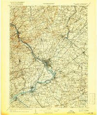
~ Trenton NJ topo map, 1:125000 scale, 30 X 30 Minute, Historical, 1907, updated 1917
Trenton, New Jersey, USGS topographic map dated 1907.
Includes geographic coordinates (latitude and longitude). This topographic map is suitable for hiking, camping, and exploring, or framing it as a wall map.
Printed on-demand using high resolution imagery, on heavy weight and acid free paper, or alternatively on a variety of synthetic materials.
Topos available on paper, Waterproof, Poly, or Tyvek. Usually shipping rolled, unless combined with other folded maps in one order.
- Product Number: USGS-8527899
- Free digital map download (high-resolution, GeoPDF): Trenton, New Jersey (file size: 9 MB)
- Map Size: please refer to the dimensions of the GeoPDF map above
- Weight (paper map): ca. 55 grams
- Map Type: POD USGS Topographic Map
- Map Series: HTMC
- Map Verison: Historical
- Cell ID: 66807
- Scan ID: 255451
- Imprint Year: 1917
- Edit Year: 1905
- Survey Year: 1888
- Datum: Unstated
- Map Projection: Unstated
- Map published by United States Geological Survey
- Map Language: English
- Scanner Resolution: 600 dpi
- Map Cell Name: Trenton
- Grid size: 30 X 30 Minute
- Date on map: 1907
- Map Scale: 1:125000
- Geographical region: New Jersey, United States
Neighboring Maps:
All neighboring USGS topo maps are available for sale online at a variety of scales.
Spatial coverage:
Topo map Trenton, New Jersey, covers the geographical area associated the following places:
- Ellisdale - Franklin Corner - Harbourton - Longmead Farms - Windsor - Moore - Mechanicsville - Zion - Prospect Park - Brookwood - Walnford - Hillside Terrace - Beverly - Sunset Hill Garden - Sharon - Princeton Meadows - Riverside Park - Garfield Park East - Edgely - Parkway Village - Sergeantsville - Sharp - Titusville - Crabtree Hollow - Hood - North Crosswicks - Sykesville - Mile Hollow - Vermilion Hill - Yardville Heights - Wood - Mercerville - Deans - Washington Crossing - Jacksonville - Linconia - Pages Corner - Fairless Hills - Neshaminy (historical) - Fairview - North Princeton - Haines Corner - Rileyville - Parsonville - Emilie - Trenton Gardens - Woodbourne - Shrewsbury - Dilts Corner - Reaville - Farmbrook - Center Bridge - Brindletown - Bridgewater - Scammells Corner - Carriage Stop - Cranbury - Newportville Terrace - New Hope - Millstone - Chewalla Park - Sandy Ridge - Ringoes - Indian Creek - Bridgetown - Hellings Corner - Chambers Corners - Eddington Park - Bustleton - Wrightstown - Oaktree Hollow - Homes Mills - Charleston - Snydertown - Clarksville - Dunlap - Sylvan Glen - Timbuctoo - Harneys Corner - Dunns Mills - Sand Hills - Borton Landing - Bristol - Bordentown - Morrell Park - Fergusonville - Somerset - Mill Creek Falls - Villas of Middletown - Normandy - Newtown Grant - Pine Lane - Tullytown - Rosedale - Rosemont - Cornwells Manor - Upper Emilie - Plainsboro - Springfield - Cedar Grove
- Map Area ID: AREA40.540-75-74.5
- Northwest corner Lat/Long code: USGSNW40.5-75
- Northeast corner Lat/Long code: USGSNE40.5-74.5
- Southwest corner Lat/Long code: USGSSW40-75
- Southeast corner Lat/Long code: USGSSE40-74.5
- Northern map edge Latitude: 40.5
- Southern map edge Latitude: 40
- Western map edge Longitude: -75
- Eastern map edge Longitude: -74.5


