
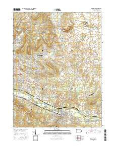
~ Birdsboro PA topo map, 1:24000 scale, 7.5 X 7.5 Minute, 2016
Birdsboro, Pennsylvania, USGS topographic map dated 2016.
Includes geographic coordinates (latitude and longitude). This topographic map is suitable for hiking, camping, and exploring, or framing it as a wall map.
Printed on-demand using high resolution imagery, on heavy weight and acid free paper, or alternatively on a variety of synthetic materials.
Topos available on paper, Waterproof, Poly, or Tyvek. Usually shipping rolled, unless combined with other folded maps in one order.
- Product Number: USGS-8259837
- Free digital map download (high-resolution, GeoPDF): Birdsboro, Pennsylvania (file size: 25 MB)
- Map Size: please refer to the dimensions of the GeoPDF map above
- Weight (paper map): ca. 55 grams
- Map Type: POD USGS Topographic Map
- Map Series: US Topo
- Map Verison: Current
- Cell ID: 3990
- Datum: North American Datum of 1983
- Map Projection: Transverse Mercator
- Map Cell Name: Birdsboro
- Grid size: 7.5 X 7.5 Minute
- Date on map: 2016
- Map Scale: 1:24000
- Geographical region: Pennsylvania, United States
Neighboring Maps:
All neighboring USGS topo maps are available for sale online at a variety of scales.
Spatial coverage:
Topo map Birdsboro, Pennsylvania, covers the geographical area associated the following places:
- Gibraltar - Exeter Golf Club Estates - Mexico (historical) - Golfshire Hills - Heisters Creek - Oley Line - Linstead - Browns Mill - Green Tree Acres - Griesemersville - Valley View Mobile Homes - Wyndham Hill - Valley View Acres - High Meadow Estates - Ramblewood - Overlook Woods - Silvertown (historical) - Reading Manor - Valley Ridge Farms - Furnace Hill (historical) - Mountain Park - Lincolnwood - Reiffton - Glen Oley Farms - Stonersville - Kinsey Hill - Beidlertown (historical) - Westridge - Texas (historical) - Stonetown - Brice Village - Pathfinder Valley - AVM Estates - Weavertown - Wingspread - Fairview Park - Monocacy - Lincolntown (historical) - Pheasant Run - Country Club Run - Hohls Crossing - Penn View Mobile Home Park - Long Pond - Yellow House - Lorane Orchards - Sunshine - Sunrise - Fairway - Devon Green - Forest Court - Five Points - Saint Lawrence - Farming Ridge - Lorane - Grist Mill Farms - Mount Airy - Robeson Crossing - Bordic Trailer Park - South Birdsboro (historical) - Beavers Mill - Sandy Run East - Greenview - Jacksonwald - Limekiln - Laurel Springs - Monocacy Station - Birdsboro - Eastwick - Jackson Meadows - Marywood - Baumstown - Country Club Run II - Hunters Run - Sunset Manor - Schwarzwald Heights - Greisemersville - Stony Creek Mills - Exeter Village - Brooklyn (historical) - Pineland
- Map Area ID: AREA40.37540.25-75.875-75.75
- Northwest corner Lat/Long code: USGSNW40.375-75.875
- Northeast corner Lat/Long code: USGSNE40.375-75.75
- Southwest corner Lat/Long code: USGSSW40.25-75.875
- Southeast corner Lat/Long code: USGSSE40.25-75.75
- Northern map edge Latitude: 40.375
- Southern map edge Latitude: 40.25
- Western map edge Longitude: -75.875
- Eastern map edge Longitude: -75.75


