
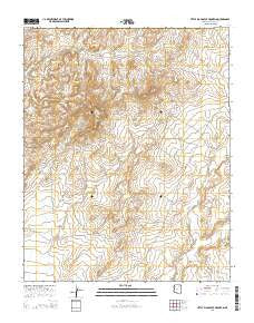
~ Little Black Spot Mountain AZ topo map, 1:24000 scale, 7.5 X 7.5 Minute, 2014
Little Black Spot Mountain, Arizona, USGS topographic map dated 2014.
Includes geographic coordinates (latitude and longitude). This topographic map is suitable for hiking, camping, and exploring, or framing it as a wall map.
Printed on-demand using high resolution imagery, on heavy weight and acid free paper, or alternatively on a variety of synthetic materials.
Topos available on paper, Waterproof, Poly, or Tyvek. Usually shipping rolled, unless combined with other folded maps in one order.
- Product Number: USGS-7239515
- Free digital map download (high-resolution, GeoPDF): Little Black Spot Mountain, Arizona (file size: 27 MB)
- Map Size: please refer to the dimensions of the GeoPDF map above
- Weight (paper map): ca. 55 grams
- Map Type: POD USGS Topographic Map
- Map Series: US Topo
- Map Verison: Current
- Cell ID: 25922
- Datum: North American Datum of 1983
- Map Projection: Transverse Mercator
- Map Cell Name: Little Black Spot Mountain
- Grid size: 7.5 X 7.5 Minute
- Date on map: 2014
- Map Scale: 1:24000
- Geographical region: Arizona, United States
Neighboring Maps:
All neighboring USGS topo maps are available for sale online at a variety of scales.
Spatial coverage:
Topo map Little Black Spot Mountain, Arizona, covers the geographical area associated the following places:
- Hastiin Akahibito - Under Rock Spring - Pigeon Spring - Rough Rock Spring - Crooked Finger Spring - Rough Rock Well - Tolah Nascin - Chilchinbeto - Little Black Spot Mountain - Togoholtsoe Spring - Ponderosa Pine Spring - Pack Rat Spring
- Map Area ID: AREA36.12536-110.375-110.25
- Northwest corner Lat/Long code: USGSNW36.125-110.375
- Northeast corner Lat/Long code: USGSNE36.125-110.25
- Southwest corner Lat/Long code: USGSSW36-110.375
- Southeast corner Lat/Long code: USGSSE36-110.25
- Northern map edge Latitude: 36.125
- Southern map edge Latitude: 36
- Western map edge Longitude: -110.375
- Eastern map edge Longitude: -110.25


