
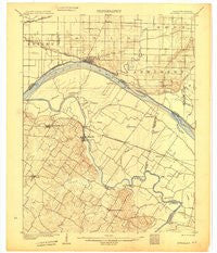
~ Newburg IN topo map, 1:62500 scale, 15 X 15 Minute, Historical, 1905
Newburg, Indiana, USGS topographic map dated 1905.
Includes geographic coordinates (latitude and longitude). This topographic map is suitable for hiking, camping, and exploring, or framing it as a wall map.
Printed on-demand using high resolution imagery, on heavy weight and acid free paper, or alternatively on a variety of synthetic materials.
Topos available on paper, Waterproof, Poly, or Tyvek. Usually shipping rolled, unless combined with other folded maps in one order.
- Product Number: USGS-6063245
- Free digital map download (high-resolution, GeoPDF): Newburg, Indiana (file size: 6 MB)
- Map Size: please refer to the dimensions of the GeoPDF map above
- Weight (paper map): ca. 55 grams
- Map Type: POD USGS Topographic Map
- Map Series: HTMC
- Map Verison: Historical
- Cell ID: 58404
- Scan ID: 709371
- Survey Year: 1903
- Datum: Unstated
- Map Projection: Unstated
- Map published by United States Geological Survey
- Map Language: English
- Scanner Resolution: 508 dpi
- Map Cell Name: Newburgh
- Grid size: 15 X 15 Minute
- Date on map: 1905
- Map Scale: 1:62500
- Geographical region: Indiana, United States
Neighboring Maps:
All neighboring USGS topo maps are available for sale online at a variety of scales.
Spatial coverage:
Topo map Newburg, Indiana, covers the geographical area associated the following places:
- Laketown (historical) - Rustic Hills - Bluff City - Birk City - Zion - Newburgh - Yankeetown - Scuffletown - Newman - Pyeattville - Sauer (historical) - Camp Brosend - Hillcrest Terrace - Smythe - Vanada - Spottsville - Baskett - Paradise - Reed - Carlinburg - Pelzer - Beals - Red Bush - Hebbardsville - Dayville
- Map Area ID: AREA3837.75-87.5-87.25
- Northwest corner Lat/Long code: USGSNW38-87.5
- Northeast corner Lat/Long code: USGSNE38-87.25
- Southwest corner Lat/Long code: USGSSW37.75-87.5
- Southeast corner Lat/Long code: USGSSE37.75-87.25
- Northern map edge Latitude: 38
- Southern map edge Latitude: 37.75
- Western map edge Longitude: -87.5
- Eastern map edge Longitude: -87.25


