
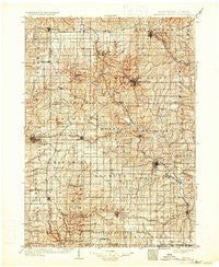
~ Mineral Point WI topo map, 1:125000 scale, 30 X 30 Minute, Historical, 1902, updated 1933
Mineral Point, Wisconsin, USGS topographic map dated 1902.
Includes geographic coordinates (latitude and longitude). This topographic map is suitable for hiking, camping, and exploring, or framing it as a wall map.
Printed on-demand using high resolution imagery, on heavy weight and acid free paper, or alternatively on a variety of synthetic materials.
Topos available on paper, Waterproof, Poly, or Tyvek. Usually shipping rolled, unless combined with other folded maps in one order.
- Product Number: USGS-6007148
- Free digital map download (high-resolution, GeoPDF): Mineral Point, Wisconsin (file size: 8 MB)
- Map Size: please refer to the dimensions of the GeoPDF map above
- Weight (paper map): ca. 55 grams
- Map Type: POD USGS Topographic Map
- Map Series: HTMC
- Map Verison: Historical
- Cell ID: 66062
- Scan ID: 801228
- Imprint Year: 1933
- Survey Year: 1900
- Datum: Unstated
- Map Projection: Polyconic
- Map published by United States Geological Survey
- Map Language: English
- Scanner Resolution: 508 dpi
- Map Cell Name: Mineral Point
- Grid size: 30 X 30 Minute
- Date on map: 1902
- Map Scale: 1:125000
- Geographical region: Wisconsin, United States
Neighboring Maps:
All neighboring USGS topo maps are available for sale online at a variety of scales.
Spatial coverage:
Topo map Mineral Point, Wisconsin, covers the geographical area associated the following places:
- Benton - Hazel Green - Linden - Fayette - Dodgeville - Mineral Point - Calamine - Montfort - Ipswich - Slateford - Rewey - Mifflin - Arthur - Jonesdale - Riverside - Elmo - New Diggings - Meekers Grove - Bigpatch - Waldwick - Darlington - Apple River - Saint Rose - Etna - Georgetown - Edmund - Truman - Jenkinsville - Cuba City - Dunbarton - Strawbridge - Leslie - Red Rock - Elk Grove - Belmont - Shullsburg - White Oak - Cobb - Avon - Lead Mine - Gratiot - Livingston - Platteville
- Map Area ID: AREA4342.5-90.5-90
- Northwest corner Lat/Long code: USGSNW43-90.5
- Northeast corner Lat/Long code: USGSNE43-90
- Southwest corner Lat/Long code: USGSSW42.5-90.5
- Southeast corner Lat/Long code: USGSSE42.5-90
- Northern map edge Latitude: 43
- Southern map edge Latitude: 42.5
- Western map edge Longitude: -90.5
- Eastern map edge Longitude: -90


