
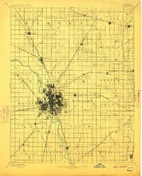
~ Wichita KS topo map, 1:125000 scale, 30 X 30 Minute, Historical, 1894, updated 1910
Wichita, Kansas, USGS topographic map dated 1894.
Includes geographic coordinates (latitude and longitude). This topographic map is suitable for hiking, camping, and exploring, or framing it as a wall map.
Printed on-demand using high resolution imagery, on heavy weight and acid free paper, or alternatively on a variety of synthetic materials.
Topos available on paper, Waterproof, Poly, or Tyvek. Usually shipping rolled, unless combined with other folded maps in one order.
- Product Number: USGS-5974374
- Free digital map download (high-resolution, GeoPDF): Wichita, Kansas (file size: 6 MB)
- Map Size: please refer to the dimensions of the GeoPDF map above
- Weight (paper map): ca. 55 grams
- Map Type: POD USGS Topographic Map
- Map Series: HTMC
- Map Verison: Historical
- Cell ID: 66942
- Scan ID: 122729
- Imprint Year: 1910
- Survey Year: 1888
- Datum: Unstated
- Map Projection: Unstated
- Map published by United States Geological Survey
- Map Language: English
- Scanner Resolution: 600 dpi
- Map Cell Name: Wichita
- Grid size: 30 X 30 Minute
- Date on map: 1894
- Map Scale: 1:125000
- Geographical region: Kansas, United States
Neighboring Maps:
All neighboring USGS topo maps are available for sale online at a variety of scales.
Spatial coverage:
Topo map Wichita, Kansas, covers the geographical area associated the following places:
- Lifestyle Mobile Home Park - Browns Mobile Home Park - Conestoga Mobile Home Park - Harbor Mobile Home Park - Kechi - Lakeside Manufactured Home Community - Van Arsdale - Potwin - Hidden Park Mobile Home Park - Rolling Meadows Mobile Home Park - McLains - Pine Ridge Manufactured Housing Community - Andover - Glenville - Tolerville - Arthur Heights - Young Mobile Home Park - Silver Spur III Mobile Home Park - Prairie Village - Trails View - Sleepy Hollow Mobile Home Park - Caudill Mobile Home Park - Sedgwick - Mathis Mobile Home Park - Tyler - Cottonwood Grove Mobile Home Park - Haysville - Reds Mobile Home Park - Wego-Waco - Pacesetter Mobile Home Park - Deer Lake Mobile Home Estates - Dahna Mobile Home Park - Eastborough - Chisholm Creek Manor Mobile Home Park - Cambridge Mobile Home Park - Cow Town - Stroud Mobile Home Park - Countryside Mobile Home Park - Park City - Keeler - Bonnie Brae - Riverside - Greenwich - MacArthur Place Mobile Home Park - Wichita Heights - Orchard Park Mobile Home Park - Brookhaven - Benton - Park Avenue Estates Mobile Home Park - Oaks Mobile Home Park - Thompsons Mobile Home Park - Willowood Estates Mobile Home Park - Stonegate Mobile Home Park - Twin Oaks Estates Mobile Home Park - Prairie Hills Mobile Home Park - Hardison Shady Acres Mobile Home Park - Schulte - Derby - Andover Mobile Home Estates - Second Addition Mobile Home Park - Park East - Valley Center - Park Place Mobile Home Park - Waco - Lakeside Acres - Sunset Acres - Rolling Hills - Annelly - Childs Acres - South Seneca Gardens - Mecca Acres - County Acres - Southborough Estates Mobile Home Park - Welcome Home Community Mobile Home Park - Furley - El Caudillo Mobile Home Park - Sunnydale - Navajo Lake Estates Mobile Home Park - Maize - Douglass - Oakwood Manor Mobile Home Park - Mona Kay Heights - Minneha - Brainerd - Pinaire Mobile Home Park - Midland Tower - Fishin Mobile Home Park - S and L Mobile Home Park - Peachwood Manor Mobile Home Park - Sand Burr Hill - Audora Mobile Home Park - Reed - A - Way Mobile Home Park - Air Capital Mobile Home Park - Salter - Midland - Lynwood Acres Mobile Home Park - Perrine Mobile Home Park - Murray Gill - Longbranch Mobile Home Park - Pleasant Valley Mobile Home Park
- Map Area ID: AREA3837.5-97.5-97
- Northwest corner Lat/Long code: USGSNW38-97.5
- Northeast corner Lat/Long code: USGSNE38-97
- Southwest corner Lat/Long code: USGSSW37.5-97.5
- Southeast corner Lat/Long code: USGSSE37.5-97
- Northern map edge Latitude: 38
- Southern map edge Latitude: 37.5
- Western map edge Longitude: -97.5
- Eastern map edge Longitude: -97


