
~ Frederiksted VI topo map, 1:24000 scale, 7.5 X 7.5 Minute, Historical, 1958, updated 1983
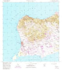
Frederiksted, Virgin Islands, USGS topographic map dated 1958.
Includes geographic coordinates (latitude and longitude). This topographic map is suitable for hiking, camping, and exploring, or framing it as a wall map.
Printed on-demand using high resolution imagery, on heavy weight and acid free paper, or alternatively on a variety of synthetic materials.
Topos available on paper, Waterproof, Poly, or Tyvek. Usually shipping rolled, unless combined with other folded maps in one order.
- Product Number: USGS-5953375
- Free digital map download (high-resolution, GeoPDF): Frederiksted, Virgin Islands (file size: 17 MB)
- Map Size: please refer to the dimensions of the GeoPDF map above
- Weight (paper map): ca. 55 grams
- Map Type: POD USGS Topographic Map
- Map Series: HTMC
- Map Verison: Historical
- Cell ID: 16323
- Scan ID: 462215
- Imprint Year: 1983
- Woodland Tint: Yes
- Photo Revision Year: 1982
- Aerial Photo Year: 1954
- Field Check Year: 1958
- Datum: Puerto Rico
- Map Projection: Polyconic
- Map published by United States Geological Survey
- Map Language: English
- Scanner Resolution: 600 dpi
- Map Cell Name: Frederiksted
- Grid size: 7.5 X 7.5 Minute
- Date on map: 1958
- Map Scale: 1:24000
- Geographical region: Virgin Islands, United States
Neighboring Maps:
All neighboring USGS topo maps are available for sale online at a variety of scales.
Spatial coverage:
Topo map Frederiksted, Virgin Islands, covers the geographical area associated the following places:
- Diamond - Hogensborg - Plessen - Hams Bay - Beck Grove - Good Hope - William - Fountain - Concordia - Frederiksted - La Grange - Hesselberg - Paradise - Smithfield - Butler Bay - North Star - Negro Bay - La Vallee - Wheel of Fortune - Golden Grove - Two Brothers - Orangegrove - Hope - North Side - Sprat Hall Beach - Cane Valley - Hermitage - Andrin (historical) - Concordia - Grove Place - Whim - Cooper - Whites Bay - Camporico - Frederiks Haab - Envy - Canebay - Prosperity - Springfield - Bodkin - Allandale - Carlton - Robe Hill - Coble - Waldberggaard - Parasol - Upper Love - Montpellier - Fort Frederick - Cane - Ruan Bay - Jealousy - Annaly - Pleasant Vale - Oxford - Nicholas - Punch - Mount Pleasant - Hard Labour - Jolly Hill - Lower Love - Sandy Point - Williams Delight - Bettys Hope
- Map Area ID: AREA17.817.675-64.925-64.8
- Northwest corner Lat/Long code: USGSNW17.8-64.925
- Northeast corner Lat/Long code: USGSNE17.8-64.8
- Southwest corner Lat/Long code: USGSSW17.675-64.925
- Southeast corner Lat/Long code: USGSSE17.675-64.8
- Northern map edge Latitude: 17.8
- Southern map edge Latitude: 17.675
- Western map edge Longitude: -64.925
- Eastern map edge Longitude: -64.8


