
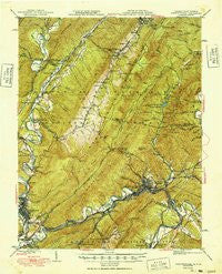
~ Clifton Forge VA topo map, 1:62500 scale, 15 X 15 Minute, Historical, 1949
Clifton Forge, Virginia, USGS topographic map dated 1949.
Includes geographic coordinates (latitude and longitude). This topographic map is suitable for hiking, camping, and exploring, or framing it as a wall map.
Printed on-demand using high resolution imagery, on heavy weight and acid free paper, or alternatively on a variety of synthetic materials.
Topos available on paper, Waterproof, Poly, or Tyvek. Usually shipping rolled, unless combined with other folded maps in one order.
- Product Number: USGS-5932335
- Free digital map download (high-resolution, GeoPDF): Clifton Forge, Virginia (file size: 12 MB)
- Map Size: please refer to the dimensions of the GeoPDF map above
- Weight (paper map): ca. 55 grams
- Map Type: POD USGS Topographic Map
- Map Series: HTMC
- Map Verison: Historical
- Cell ID: 52694
- Scan ID: 253454
- Woodland Tint: Yes
- Datum: Unstated
- Map Projection: Polyconic
- Map published by United States Geological Survey
- Map Language: English
- Scanner Resolution: 600 dpi
- Map Cell Name: Clifton Forge
- Grid size: 15 X 15 Minute
- Date on map: 1949
- Map Scale: 1:62500
- Geographical region: Virginia, United States
Neighboring Maps:
All neighboring USGS topo maps are available for sale online at a variety of scales.
Spatial coverage:
Topo map Clifton Forge, Virginia, covers the geographical area associated the following places:
- Fairview Heights - Iron Gate - Midway - Greenwood - Cliftondale Park - Greenwood (historical) - Fairlawn - Intervale - Tinkertown - Valley View - Perkins Point - Kincaid - Ashwood - Covington - Callison - Rivermont - Carloover - Healing Springs - Clifton Forge - Edgemont - Idlewilde - Selma - Falling Spring - Hot Springs - Clearwater Park - Rich Patch Mines - Glen Wilton - Longdale - Harrington - Low Moor - Mallow - Rayon Terrace - Parrish Court
- Map Area ID: AREA3837.75-80-79.75
- Northwest corner Lat/Long code: USGSNW38-80
- Northeast corner Lat/Long code: USGSNE38-79.75
- Southwest corner Lat/Long code: USGSSW37.75-80
- Southeast corner Lat/Long code: USGSSE37.75-79.75
- Northern map edge Latitude: 38
- Southern map edge Latitude: 37.75
- Western map edge Longitude: -80
- Eastern map edge Longitude: -79.75


