
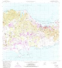
~ Christiansted VI topo map, 1:24000 scale, 7.5 X 7.5 Minute, Historical, 1958, updated 1988
Christiansted, Virgin Islands, USGS topographic map dated 1958.
Includes geographic coordinates (latitude and longitude). This topographic map is suitable for hiking, camping, and exploring, or framing it as a wall map.
Printed on-demand using high resolution imagery, on heavy weight and acid free paper, or alternatively on a variety of synthetic materials.
Topos available on paper, Waterproof, Poly, or Tyvek. Usually shipping rolled, unless combined with other folded maps in one order.
- Product Number: USGS-5932241
- Free digital map download (high-resolution, GeoPDF): Christiansted, Virgin Islands (file size: 13 MB)
- Map Size: please refer to the dimensions of the GeoPDF map above
- Weight (paper map): ca. 55 grams
- Map Type: POD USGS Topographic Map
- Map Series: HTMC
- Map Verison: Historical
- Cell ID: 8667
- Scan ID: 462195
- Imprint Year: 1988
- Woodland Tint: Yes
- Visual Version Number: 2
- Photo Revision Year: 1982
- Aerial Photo Year: 1977
- Edit Year: 1982
- Field Check Year: 1958
- Datum: Puerto Rico
- Map Projection: Polyconic
- Map published by United States Geological Survey
- Map Language: English
- Scanner Resolution: 600 dpi
- Map Cell Name: Christiansted
- Grid size: 7.5 X 7.5 Minute
- Date on map: 1958
- Map Scale: 1:24000
- Geographical region: Virgin Islands, United States
Neighboring Maps:
All neighboring USGS topo maps are available for sale online at a variety of scales.
Spatial coverage:
Topo map Christiansted, Virgin Islands, covers the geographical area associated the following places:
- Nugent - Limetree - La Reine - Morningstar - Friedensfeld - Fredensdal - Bellevue - Diamond - Hope - Little Fountain - Jerusalem and Figtree Hill - Annaberg - Rattan and Belvedere - Glynn - Bonne Esperance - Kingshill - Bethlehem Old Work - Castle Coakley - Ruby - Munster - Concordia - Anguilla - Montpellier - Profit - Orange Grove - Christiansted - Saint John - Grange - Cathrines Rest - Saint Peter - Upper Bethlehem - Altona - Sion Farm - Peters Rest - Humbug - La Grande Princesse - Bulows Minde - Slob - Canaan - Alderhvile (historical) - Clairmont - Granard - Sunny Isle - Sion Hill - Bugbyhole - Laprey Valley - Diamond Keturah - Longford - Pearl - Belvedere - Richmond - Blessing - Windsor - Clifton Hill - Ryan - Fredensborg - Strawberry Hill - Butzberg - Recovery Hill - Mon Bijou - Betzys Jewell - Spanish Town - Annas Hope - Shoys - Beeston Hill - Libanon Hill - Contentment
- Map Area ID: AREA17.817.675-64.8-64.675
- Northwest corner Lat/Long code: USGSNW17.8-64.8
- Northeast corner Lat/Long code: USGSNE17.8-64.675
- Southwest corner Lat/Long code: USGSSW17.675-64.8
- Southeast corner Lat/Long code: USGSSE17.675-64.675
- Northern map edge Latitude: 17.8
- Southern map edge Latitude: 17.675
- Western map edge Longitude: -64.8
- Eastern map edge Longitude: -64.675


