
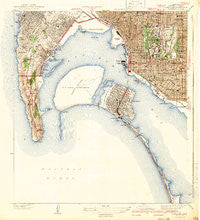
~ Point Loma CA topo map, 1:31680 scale, 7.5 X 7.5 Minute, Historical, 1942
Point Loma, California, USGS topographic map dated 1942.
Includes geographic coordinates (latitude and longitude). This topographic map is suitable for hiking, camping, and exploring, or framing it as a wall map.
Printed on-demand using high resolution imagery, on heavy weight and acid free paper, or alternatively on a variety of synthetic materials.
Topos available on paper, Waterproof, Poly, or Tyvek. Usually shipping rolled, unless combined with other folded maps in one order.
- Product Number: USGS-5688530
- Free digital map download (high-resolution, GeoPDF): Point Loma, California (file size: 9 MB)
- Map Size: please refer to the dimensions of the GeoPDF map above
- Weight (paper map): ca. 55 grams
- Map Type: POD USGS Topographic Map
- Map Series: HTMC
- Map Verison: Historical
- Cell ID: 396054
- Scan ID: 296422
- Woodland Tint: Yes
- Survey Year: 1939
- Datum: NAD27
- Map Projection: Polyconic
- Map published by United States Geological Survey
- Keywords: Overedge with No Adjacent Map
- Map Language: English
- Scanner Resolution: 600 dpi
- Map Cell Name: Point Loma
- Grid size: 7.5 X 7.5 Minute
- Date on map: 1942
- Map Scale: 1:31680
- Geographical region: California, United States
Neighboring Maps:
All neighboring USGS topo maps are available for sale online at a variety of scales.
Spatial coverage:
Topo map Point Loma, California, covers the geographical area associated the following places:
- Barrio Logan - Golden Hill - Loma Portal - Grant Hill - Logan Heights - Five Points - Tent City (historical) - San Diego - Coronado - Brooklyn Heights - La Playa - North Park - South Park - Riviera Villas - Fleetridge - Fort Rosecrans - Roseville - Sherman Heights - Sunset Cliffs - Ocean Beach - Hillcrest
- Map Area ID: AREA32.7532.625-117.2583333-117.125
- Northwest corner Lat/Long code: USGSNW32.75-117.2583333
- Northeast corner Lat/Long code: USGSNE32.75-117.125
- Southwest corner Lat/Long code: USGSSW32.625-117.2583333
- Southeast corner Lat/Long code: USGSSE32.625-117.125
- Northern map edge Latitude: 32.75
- Southern map edge Latitude: 32.625
- Western map edge Longitude: -117.2583333
- Eastern map edge Longitude: -117.125


