
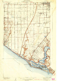
~ Newport Beach CA topo map, 1:31680 scale, 7.5 X 7.5 Minute, Historical, 1935
Newport Beach, California, USGS topographic map dated 1935.
Includes geographic coordinates (latitude and longitude). This topographic map is suitable for hiking, camping, and exploring, or framing it as a wall map.
Printed on-demand using high resolution imagery, on heavy weight and acid free paper, or alternatively on a variety of synthetic materials.
Topos available on paper, Waterproof, Poly, or Tyvek. Usually shipping rolled, unless combined with other folded maps in one order.
- Product Number: USGS-5688510
- Free digital map download (high-resolution, GeoPDF): Newport Beach, California (file size: 8 MB)
- Map Size: please refer to the dimensions of the GeoPDF map above
- Weight (paper map): ca. 55 grams
- Map Type: POD USGS Topographic Map
- Map Series: HTMC
- Map Verison: Historical
- Cell ID: 72692
- Scan ID: 296345
- Survey Year: 1932
- Datum: NAD27
- Map Projection: Polyconic
- Map published by United States Geological Survey
- Keywords: Overedge
- Map Language: English
- Scanner Resolution: 600 dpi
- Map Cell Name: Newport Beach
- Grid size: 7.5 X 7.5 Minute
- Date on map: 1935
- Map Scale: 1:31680
- Geographical region: California, United States
Neighboring Maps:
All neighboring USGS topo maps are available for sale online at a variety of scales.
Spatial coverage:
Topo map Newport Beach, California, covers the geographical area associated the following places:
- Villa Huntington Mobile Home Park - Huntington Mobile Home Estates - La Bolsa - Smeltzer - Villa Magnolia Mobile Home Park - Driftwood Mobile Home Park - Kona Kai Mobile Home Park - Liberty Park - Rancho La Siesta Mobile Home Park - Royal Gardens Mobile Home Estates - Bolsa - Ebbtide Mobile Home Park - Lake Park Santa Ana - Rancho Huntington Mobile Home Park - Fairview Mobile Home Estates - Seacliffe Mobile Home Park - Gardners Trailer Park - Newport Marina Mobile Home Park - Bolsa Verde - The Gables - Newport Beach - Pacific Trailer Park - El Nido Mobile Home Estates (historical) - Balboa Island - Sandalwood Mobile Home Park - Hyde Park Mobile Home Estates - Tradewinds Trailer Village - Harbor Mobile Home Park - Town and Country Villa - Cliff Haven - Liberty Mobile Home Court - Cannery Village Mobile Home Park - Paularino - Quiet Village Mobile Home Park - Midway City - Balboa - Brookfield Manor Mobile Home Park - Talbert - Newport Terrace Mobile Home Park - Caravana Trailer Lodge - Fountain Valley Mobile Home Estates - Greenleaf Mobile Home Park - California Mobile Home Park - Taggin Wagon Mobile Home Park - Snug Harbor Trailer Park (historical) - Bay Shores - Santa Ana Gardens - Hoosier Trailer Court - Colonia Juarez - Huntington Shorecliffs Mobile Home Park - Santa Ana Heights - Play Port Mobile Home Village - Ponderosa Mobile Home Park - Island View Trailer Park - Del Prado Bolsa - Huntington Beach - Kensington Gardens - Thurin - Boulevard Gardens - Bit-O-Home Trailer Park - Plaza Mobile Home Estates - Coach Royal Trailer Park - Stoneridge Mobile Home Park - Sugar (historical) - Rancho del Sol Mobile Home Park - Regal Mobile Club Estates - Newport Heights - Wintersburg - Fountain Valley - Lido Isle - Costa Mesa - Ocean View - Bali-Hi Mobile Home Lodge - Costa Mesa Mobile Home Estates
- Map Area ID: AREA33.7533.5833333-118-117.875
- Northwest corner Lat/Long code: USGSNW33.75-118
- Northeast corner Lat/Long code: USGSNE33.75-117.875
- Southwest corner Lat/Long code: USGSSW33.5833333-118
- Southeast corner Lat/Long code: USGSSE33.5833333-117.875
- Northern map edge Latitude: 33.75
- Southern map edge Latitude: 33.5833333
- Western map edge Longitude: -118
- Eastern map edge Longitude: -117.875


