
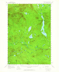
~ Spencer Lake ME topo map, 1:62500 scale, 15 X 15 Minute, Historical, 1958, updated 1965
Spencer Lake, Maine, USGS topographic map dated 1958.
Includes geographic coordinates (latitude and longitude). This topographic map is suitable for hiking, camping, and exploring, or framing it as a wall map.
Printed on-demand using high resolution imagery, on heavy weight and acid free paper, or alternatively on a variety of synthetic materials.
Topos available on paper, Waterproof, Poly, or Tyvek. Usually shipping rolled, unless combined with other folded maps in one order.
- Product Number: USGS-5685203
- Free digital map download (high-resolution, GeoPDF): Spencer Lake, Maine (file size: 8 MB)
- Map Size: please refer to the dimensions of the GeoPDF map above
- Weight (paper map): ca. 55 grams
- Map Type: POD USGS Topographic Map
- Map Series: HTMC
- Map Verison: Historical
- Cell ID: 62835
- Scan ID: 460901
- Imprint Year: 1965
- Woodland Tint: Yes
- Survey Year: 1928
- Datum: NAD27
- Map Projection: Polyconic
- Map published by United States Geological Survey
- Map Language: English
- Scanner Resolution: 600 dpi
- Map Cell Name: Spencer Lake
- Grid size: 15 X 15 Minute
- Date on map: 1958
- Map Scale: 1:62500
- Geographical region: Maine, United States
Neighboring Maps:
All neighboring USGS topo maps are available for sale online at a variety of scales.
Spatial coverage:
Topo map Spencer Lake, Maine, covers the geographical area associated the following places:
- Spencer Bale Mountain - Gold Brook - Cedar Pond - Lost Pond - Whipple Bog - Mud Pond - Iron Pond - Chub Pond - King and Bartlett Camps - Lower Shaw Pond - Long Pond - Beck Pond - Davis Brook - Joe Pokum Pond - Kibby Stream - Spencer Lake Dam - King and Bartlett Township - Baker Pond - Spectacle Pond - Davis Pond - Little King Lake - Jim Pond Brook - T3 R4 BKP WKR - Porter Pond - King and Bartlett Mountain - Fish Pond - King-Bartlett Lake Dam - Blakeslee Lake - Parker Pond - Gore Rapids - Douglas Pond - Three Slide Mountain - Whipple Pond - Spencer Gut - Little King Ridge - Spencer Lake - Hurricane Brook - Moore Pond - The Chimes - Parker Brook - Number Six Brook - Camera Hill - Bear Mountain - Felker Pond - Pickle Hill - Camera Ridge - Durgin Brook - Spencer Dam - Parker Bog Brook - Black Nubble - Appleton Township - Spencer Lake - Hobbstown Township - Hall Pond - Whit Brook - Deer Pond - Toby Pond - Little Jim Pond - Horseshoe Pond - T5 R6 BKP WKR - Farm Hill - Mud Pond - Spotted Spruce Mountain - Egg Pond - Spaulding Brook - Bear Pond - Lost Pond - Spencer Stream Dam - Shaw Pond - Rock Pond - Spencer Stream - Unorganized Territory of Northwest Somerset - Spencer Lake Camps - Otter Pond - Number Six Mountain - Baker Stream - Spencer Mountain - Black Brook - Chittenden Pond - Butler Pond - Sweetster Brook - Cold Brook - Pray Hill - Hobbstown Depot Camp - Dud Brook - King and Bartlett Lake - Greenlaw Mountain - Everett Pond - Kibby Kamp - Hardscrabble Mountain - Hedgehog Mountain - Hardwood Mountain - Tumbledown Mountain - Burnt Hill - Joe Pokum Bog - Rush Pond - West Branch Spencer Stream
- Map Area ID: AREA45.545.25-70.5-70.25
- Northwest corner Lat/Long code: USGSNW45.5-70.5
- Northeast corner Lat/Long code: USGSNE45.5-70.25
- Southwest corner Lat/Long code: USGSSW45.25-70.5
- Southeast corner Lat/Long code: USGSSE45.25-70.25
- Northern map edge Latitude: 45.5
- Southern map edge Latitude: 45.25
- Western map edge Longitude: -70.5
- Eastern map edge Longitude: -70.25


