
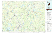
~ Skowhegan ME topo map, 1:100000 scale, 30 X 60 Minute, Historical, 1985, updated 1986
Skowhegan, Maine, USGS topographic map dated 1985.
Includes geographic coordinates (latitude and longitude). This topographic map is suitable for hiking, camping, and exploring, or framing it as a wall map.
Printed on-demand using high resolution imagery, on heavy weight and acid free paper, or alternatively on a variety of synthetic materials.
Topos available on paper, Waterproof, Poly, or Tyvek. Usually shipping rolled, unless combined with other folded maps in one order.
- Product Number: USGS-5685165
- Free digital map download (high-resolution, GeoPDF): Skowhegan, Maine (file size: 22 MB)
- Map Size: please refer to the dimensions of the GeoPDF map above
- Weight (paper map): ca. 55 grams
- Map Type: POD USGS Topographic Map
- Map Series: HTMC
- Map Verison: Historical
- Cell ID: 72656
- Scan ID: 460879
- Imprint Year: 1986
- Woodland Tint: Yes
- Aerial Photo Year: 1979
- Edit Year: 1985
- Datum: NAD27
- Map Projection: Universal Transverse Mercator
- Planimetric: Yes
- Map published by United States Geological Survey
- Map Language: English
- Scanner Resolution: 600 dpi
- Map Cell Name: Skowhegan
- Grid size: 30 X 60 Minute
- Date on map: 1985
- Map Scale: 1:100000
- Geographical region: Maine, United States
Neighboring Maps:
All neighboring USGS topo maps are available for sale online at a variety of scales.
Spatial coverage:
Topo map Skowhegan, Maine, covers the geographical area associated the following places:
- Rome Corner - Tilton Corner - South Levant - Hurd Corner - Mosher Corner - Hasty Corner - Benton Falls - East Newport - Mainstream - South Newburgh - Mitchell Corner - Reynolds Corner - Mitchell Corner - Windemere - Benton - Goodwin Corner - Burnham - Sibley Corner - Mount Vernon - Saint Albans - Miller Corner - Knox Center - Monroe Center - Smarts Corner - Hayden Corner - Nutter Corner - Stetson - Troy Center - Bog Corner - Paines Corner - Oakwood - Corinna Center - Corsons Corner - Burton Corner - East Winslow - Malbons Mills - Goodwin Corner - Stronghold - Pease Corner - Plymouth - Carmel - Arnold Corner - Rollins Mills - Phillips Corner - East Madison - Smithfield - Sanborn Corner - Billings Hill - Skowhegan - Dow Corner - French Mill - Spragues Mill - Hales Corner - Moody - South Albion - South Solon - Clinton - Fairfield Center - Manson Corner - Nash Corner - Shawmut - Marsh Corner - North Anson - Pattee Corner - Dixon Corner - Nickerson Mills - Waldo - Knox Corner - Solon - Athens - Holway Corner - Ellis Corner - Lyford Corner - Katen Corner - Halldale - Troy - Detroit - Plummer Corner - Rice Corner - Knox Hill Corner - East Exeter - Dane Corner - Arnolds Landing - Hoxies - Belgrade Lakes - East Dixmont - Lower Mill - Twitchell Corner - Embden - East Knox - Exeter Corners - Freedom - Lincoln Mills - Etna Center - Barron Corner - Ellis Corner - Dodge Corner - West Palmyra - North Belgrade - Winnecook
- Map Area ID: AREA4544.5-70-69
- Northwest corner Lat/Long code: USGSNW45-70
- Northeast corner Lat/Long code: USGSNE45-69
- Southwest corner Lat/Long code: USGSSW44.5-70
- Southeast corner Lat/Long code: USGSSE44.5-69
- Northern map edge Latitude: 45
- Southern map edge Latitude: 44.5
- Western map edge Longitude: -70
- Eastern map edge Longitude: -69


