
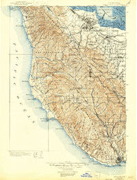
~ Santa Cruz CA topo map, 1:125000 scale, 30 X 30 Minute, Historical, 1902, updated 1946
Santa Cruz, California, USGS topographic map dated 1902.
Includes geographic coordinates (latitude and longitude). This topographic map is suitable for hiking, camping, and exploring, or framing it as a wall map.
Printed on-demand using high resolution imagery, on heavy weight and acid free paper, or alternatively on a variety of synthetic materials.
Topos available on paper, Waterproof, Poly, or Tyvek. Usually shipping rolled, unless combined with other folded maps in one order.
- Product Number: USGS-5683183
- Free digital map download (high-resolution, GeoPDF): Santa Cruz, California (file size: 11 MB)
- Map Size: please refer to the dimensions of the GeoPDF map above
- Weight (paper map): ca. 55 grams
- Map Type: POD USGS Topographic Map
- Map Series: HTMC
- Map Verison: Historical
- Cell ID: 66565
- Scan ID: 302067
- Imprint Year: 1946
- Survey Year: 1899
- Datum: Unstated
- Map Projection: Polyconic
- Map published by United States Geological Survey
- Keywords: Overedge with No Adjacent Map
- Map Language: English
- Scanner Resolution: 600 dpi
- Map Cell Name: Santa Cruz
- Grid size: 30 X 30 Minute
- Date on map: 1902
- Map Scale: 1:125000
- Geographical region: California, United States
Neighboring Maps:
All neighboring USGS topo maps are available for sale online at a variety of scales.
Spatial coverage:
Topo map Santa Cruz, California, covers the geographical area associated the following places:
- Trailer Rancho Mobile Home Park - Camp Evers - Sahara Village Mobile Home Park - Mobiland Manor Mobile Home Park - Duveneck - Rex Manor - Wildwood - Butano Park - Champagne Fountain - Grabtown - Forest Springs - The Crossings - Davenport - Henderson - Raines Houses - Stanford Hills - Sequoia Mobile Home Park - West Menlo Park - Boulder Creek - Beulah Park - Portola Valley - Santiago Villa Mobile Home Park - Willow Ranch Mobile Home Park - Accent Homes Mobile Home Park - Redwood Junction - Davenport Landing - El Dorado Mobile Home Park - Castro City - Felton - Searsville (historical) - La Honda - Escondido Village - Half Moon Bay - Woodland Acres - Saint Francis Acres - Vintage Oaks - Martins Beach - College Terrace - Vista Verde - The Highlands - Olympia - Paradise Park - Le Mar Mobile Home Park - Scotts Valley - Crescent Park - Blue Hills - Evergreen Park - Riverside Grove - Stanford Weekend Acres - Lindenwood - Mayfield - Ladera - Cooley Landing - San Gregorio - Park Forest - Saratoga - Redwood City Mobile Home Park - Bonny Doon - Felton Gables - The Greenhouse - Professorville - Belle Haven - Redwood Park - Cape Cod Village Mobile Home Park - Charleston Gardens - Plaza del Rey Mobile Home Park - Loyola Corners - Los Altos - Cuesta Park - Fox Hollow Mobile Home Park - Saint Francis - Saint Claire Gardens - Brookdale - Forest Park - Mission Springs - Rancho la Mesa Mobile Home Court - Bellvale - Southgate - Lloyden Park - Palo Alto - Menlo Oaks - Loyola - Meadow Park - Pasatiempo - Green Acres - Monroe Park - Woodside Highlands - Menlo Park - Waverly Park - Redwood City - Swanton - Belle Haven - Rincon - Greenmeadow - Emerald Lake Hills - Palo Verde - Sharon Heights - Stanford - Aloha Mobile Village - Rancho Rinconada
- Map Area ID: AREA37.537-122.5-122
- Northwest corner Lat/Long code: USGSNW37.5-122.5
- Northeast corner Lat/Long code: USGSNE37.5-122
- Southwest corner Lat/Long code: USGSSW37-122.5
- Southeast corner Lat/Long code: USGSSE37-122
- Northern map edge Latitude: 37.5
- Southern map edge Latitude: 37
- Western map edge Longitude: -122.5
- Eastern map edge Longitude: -122


